Filter: Categories of Wisconsin Historical Images
Filter: Subject of Battlefields
Filter: Subject of human settlements
Filter: Categories of Wisconsin Historical Images
Filter: Subject of Battlefields
Filter: Subject of human settlements

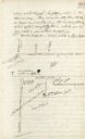
| Date: | 08 24 1876 |
|---|---|
| Description: | Hand-drawn plan of the battleground of Huycks. |

| Date: | 03 26 1876 |
|---|---|
| Description: | Hand-drawn map showing the place of Hook's defeat in York County in South Carolina. |
| Date: | 1945 |
|---|---|
| Description: | Marker on State trunk highway 78 near the intersection of Dane County Highway Y. A more recent official marker is about a mile away, at the intersection of... |
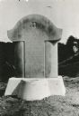
| Date: | 1930 |
|---|---|
| Description: | View of the historic site marker on Highway 35 indicating the location of Bad Axe Battlefield. Caption reads: "Tablet on Highway #35 * Victory, Wis." |

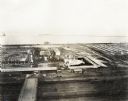
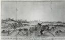
| Date: | 09 1918 |
|---|---|
| Description: | Elevated view of the U.S. Government War Exposition grounds at Grant Park. |

| Date: | 09 1918 |
|---|---|
| Description: | Elevated view of the U.S. Government War Exposition at Grant Park taken from a window the International Harvester building on Michigan Avenue. A large crow... |
| Date: | 09 1918 |
|---|---|
| Description: | Elevated view of the U.S. Government War Exposition at Grant Park taken from a window the International Harvester building on Michigan Avenue. A large crow... |
| Date: | 07 04 1863 |
|---|---|
| Description: | The surrender of Confederate troops after the battle of Vicksburg. Watercolor by Private John Gaddis of the 12th Wisconsin Volunteer Infantry, Company E. |

| Date: | 1864 |
|---|---|
| Description: | View across the Tennessee River toward the city and Cameron Hill, showing the military bridge and some Union Army installations put up following the occupa... |

| Date: | |
|---|---|
| Description: | A view of eight commemorative tablets at the North Cemetery of Antietam Battlefield, the site of the bloodiest one-day battle in United States history in 1... |
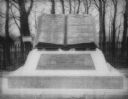
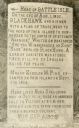
| Date: | 1890 |
|---|---|
| Description: | "Commands Honored" monument in the form of a large bronze book opened to pages reading "High Water Mark on the Rebellion" and "Repulse of Longstreet's Assa... |
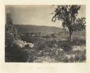
| Date: | 1866 |
|---|---|
| Description: | View of Ringgold in the far distance. A tree and pile of rubble, perhaps the remains of a fireplace, in the foreground. Plate 17 |

| Date: | 1864 |
|---|---|
| Description: | (U.S. 39th Cong. 1stt Sess. Report of Chief engineer) The legend in the upper left corner contains a brief resume of each day's action while the map sho... |

| Date: | 1864 |
|---|---|
| Description: | This map of the Battle of Gettysburg indicates Union positions in red and Confederate positions in blue. Also shown are artillery positions, roads, railroa... |

| Date: | 1876 |
|---|---|
| Description: | Detailed topographic map of the Gettysburg battlefield created thirteen years after the battle. This map shows day one of the battle. The map shows drainag... |

| Date: | 1862 |
|---|---|
| Description: | This map shows the region of southeastern Virginia which served as the setting for the Peninsular Campaign of 1862. A few battle sites are marked by crosse... |

| Date: | 1862 |
|---|---|
| Description: | This map of the Battle of Shiloh shows relief by hachures, vegetation, drainage, houses, fields, fences, mills, and roads and is color coded to show the mo... |

| Date: | 1862 |
|---|---|
| Description: | This map of the southeastern United States shows forts and battlefields, railroads, rivers, and cities and towns. Dates of admission and secession of the s... |

| Date: | 1863 |
|---|---|
| Description: | These detailed topographical maps of the Battle of Gettysburg show drainage, vegetation, roads, railroads, fences, houses with names of residents, and a de... |
If you didn't find the material you searched for, our Library Reference Staff can help.
Call our reference desk at 608-264-6535 or email us at: