 Filter: Categories of Wisconsin Historical Images
Filter: Subject of Battlefields
Filter: Subject of dwellings
Filter: Categories of Wisconsin Historical Images
Filter: Subject of Battlefields
Filter: Subject of dwellings
| Date: | |
|---|---|
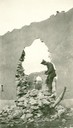
| Description: | A French house in ruins. Captioned: "Julian Bryan, standing in a hole made by a shell. Notice that French houses are constructed for centuries where Amer... |
| Date: | 1917 |
|---|---|
| Description: | Ruins of a French house. Captioned: "The first real ruins of the war that any of S.S.U. 12 ever saw. Our way to the front lead over the battlefield of th... |
| Date: | 1862 |
|---|---|
| Description: | "Battle ground in foreground where occurred the skirmish near Farmington near Corinth." Farmington church near Corinth, Mississippi. Preliminary sketch sho... |

| Date: | 07 1913 |
|---|---|
| Description: | Panoramic view of encampment for the Battle of Gettysburg 50th Anniversary, with hundreds of tents. |
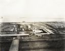
| Date: | 09 1918 |
|---|---|
| Description: | Elevated view of the U.S. Government War Exposition at Grant Park taken from a window the International Harvester building on Michigan Avenue. A large crow... |

| Date: | 08 1862 |
|---|---|
| Description: | Color lithograph of Union lines in the midst of battle. |
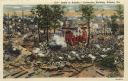
| Date: | |
|---|---|
| Description: | A view of the Cedar Mountain Battlefield. Caption reads: "Cedar Mountain Battle Field, Culpeper, VA." |
| Date: | 1890 |
|---|---|
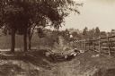
| Description: | Site of the Battle of Antietam. The bloody lane. |
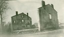
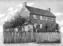
| Date: | 1900 |
|---|---|
| Description: | The famous "Shirley House" or "White House," stands near the Jackson Road, which was between the Union and Confederate entrenchments during the siege of Vi... |
| Date: | |
|---|---|
| Description: | A section of the cycloramic painting "Battle of Atlanta" in Grant Park, executed by the Milwaukee group of panorama painters working under Wilhem Wehner i... |
| Date: | |
|---|---|
| Description: | Color postcard of a section of the cyclorama painting "Battle of Atlanta" executed by painters under Wilhem Wehner in the 1880s. This scene shows the fight... |
| Date: | |
|---|---|
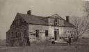
| Description: | A fence surrounds an old stone house and trees at Bull Run Battlefield. Caption reads: "Stone House, Bull Run Battlefield, Va." |
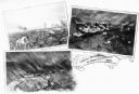
| Date: | 1862 |
|---|---|
| Description: | A composite of three views showing the siege of New Ulm on August 19 during the Indian Massacre of 1862. The lower left view depicts wagons and horses on a... |

| Date: | 1942 |
|---|---|
| Description: | Advertising proof illustrating International Harvester's contribution to the war effort through the forming of maintenance battalions to service Internatio... |
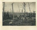
| Date: | 1866 |
|---|---|
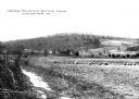
| Description: | Barren and battered trees on the Resacca battlefield. There is a house in a valley in the distance. Plate 21 |
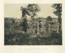
| Date: | 1866 |
|---|---|
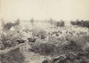
| Description: | Broken trees in front of a field with a fence. There is a small building on a hill in the background. Plate 20 |

| Date: | 1862 |
|---|---|
| Description: | This map of the Battle of Shiloh shows relief by hachures, vegetation, drainage, houses, fields, fences, mills, and roads and is color coded to show the mo... |

| Date: | 1863 |
|---|---|
| Description: | These detailed topographical maps of the Battle of Gettysburg show drainage, vegetation, roads, railroads, fences, houses with names of residents, and a de... |

| Date: | 1863 |
|---|---|
| Description: | These detailed topographical maps of the Battle of Gettysburg show drainage, vegetation, roads, railroads, fences, houses with names of residents, and a de... |

| Date: | 1863 |
|---|---|
| Description: | These detailed topographical maps of the Battle of Gettysburg show drainage, vegetation, roads, railroads, fences, houses with names of residents, and a de... |
If you didn't find the material you searched for, our Library Reference Staff can help.
Call our reference desk at 608-264-6535 or email us at: