 Filter: Categories of Wisconsin Historical Images
Filter: Subject of Battlefields
Filter: Subject of cities and towns
Filter: Subject of water
Filter: Categories of Wisconsin Historical Images
Filter: Subject of Battlefields
Filter: Subject of cities and towns
Filter: Subject of water

| Date: | 09 1918 |
|---|---|
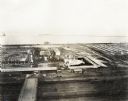
| Description: | Elevated view of the U.S. Government War Exposition grounds at Grant Park. |

| Date: | 09 1918 |
|---|---|
| Description: | Elevated view of the U.S. Government War Exposition at Grant Park taken from a window the International Harvester building on Michigan Avenue. A large crow... |
| Date: | 09 1918 |
|---|---|
| Description: | Elevated view of the U.S. Government War Exposition at Grant Park taken from a window the International Harvester building on Michigan Avenue. A large crow... |

| Date: | 1864 |
|---|---|
| Description: | View across the Tennessee River toward the city and Cameron Hill, showing the military bridge and some Union Army installations put up following the occupa... |

| Date: | 1864 |
|---|---|
| Description: | (U.S. 39th Cong. 1stt Sess. Report of Chief engineer) The legend in the upper left corner contains a brief resume of each day's action while the map sho... |

| Date: | 1862 |
|---|---|
| Description: | This map of the southeastern United States shows forts and battlefields, railroads, rivers, and cities and towns. Dates of admission and secession of the s... |

| Date: | 1863 |
|---|---|
| Description: | A general map of the southeastern United States showing Missouri, Kentucky, West Virginia, Virginia, North Carolina, South Carolina, Georgia, Florida, Alab... |

| Date: | 1864 |
|---|---|
| Description: | This map of the battlefield on the North Anna River at Hanover Junction illustrates the Union positions in blue and Confederate positions in red. Roads, ra... |

| Date: | 1864 |
|---|---|
| Description: | This colored map of the southern and eastern states shows locations of battles and skirmishes from 1861 through May 1864 with red dots or red underlining o... |

| Date: | 1915 |
|---|---|
| Description: | This 1915 map covers portions of Barron, Chippewa, and Rusk counties in Wisconsin. Shown are the township and range grid, sections, cities and villages, ra... |

| Date: | 1887 |
|---|---|
| Description: | Map of the Fox and Wisconsin Rivers to accompany Reuben Gold Thwaites' Historic Waterways. |

| Date: | 05 01 1899 |
|---|---|
| Description: | Map showing the Schuylkill River with roads, ferries, and points of interest from Valley Forge to Philadelphia, Pennsylvania as it appeared during the Revo... |

| Date: | 1865 |
|---|---|
| Description: | This map shows U.S. cavalry positions in yellow, Confederate infantry positions in blue, and Confederate cavalry positions in red. The map also shows roads... |

| Date: | 1864 |
|---|---|
| Description: | A map of Sherman's March from Atlanta, Georgia to Goldsboro, North Carolina. |
If you didn't find the material you searched for, our Library Reference Staff can help.
Call our reference desk at 608-264-6535 or email us at: