Filter: Categories of Wisconsin Historical Images
Filter: Subject of Battlefields
Filter: Creator Name of Unknown
Filter: Subject of land
Filter: Categories of Wisconsin Historical Images
Filter: Subject of Battlefields
Filter: Creator Name of Unknown
Filter: Subject of land
| Date: | |
|---|---|
| Description: | An illustration titled "The Battle of the Brule" based on an 1840's battle between the Ojibwe and Dakota Sioux over territory in the Ashland, Wisconsin are... |

| Date: | |
|---|---|
| Description: | Plan of the battle of the horse shoe bend on the East Pecatonica. |
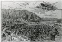
| Date: | |
|---|---|
| Description: | The Battle of Chattanooga from the Milwaukee-based American Panoramic Company's cyclorama "The Storming of Missionary Ridge." |
| Date: | |
|---|---|
| Description: | A view of the Cedar Mountain Battlefield. Caption reads: "Cedar Mountain Battle Field, Culpeper, VA." |

| Date: | 07 01 1862 |
|---|---|
| Description: | "Malvern Hill." The site of the battle in a half-toned photograph from a book. |
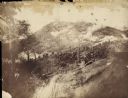
| Date: | 1902 |
|---|---|
| Description: | Confederate "Fort Hill" on the south side of Jackson Road where the Confederate entrenchments run southward. The Siege of Vicksburg lasted from May to July... |
| Date: | |
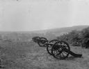
|---|---|
| Description: | A view of Lunette Batteries. Canons stand in a line and United States flags are lined up into the distance. |

| Date: | |
|---|---|
| Description: | Pen and ink tracing showing the positions of Union and Confederate soldiers, troop camps, location of graves, roads, drainage, vegetation, houses, and fenc... |

| Date: | |
|---|---|
| Description: | A map of southern Wisconsin and northern Illinois showing where the battles took place and routes taken by Black Hawk and his band during the Black Hawk Wa... |

| Date: | 1915 |
|---|---|
| Description: | This 1915 map covers portions of Barron, Chippewa, and Rusk counties in Wisconsin. Shown are the township and range grid, sections, cities and villages, ra... |

| Date: | 1887 |
|---|---|
| Description: | Map of the Fox and Wisconsin Rivers to accompany Reuben Gold Thwaites' Historic Waterways. |
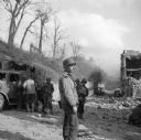
| Date: | 09 18 1944 |
|---|---|
| Description: | Robert Doyle views the destruction on a street in Brest, France. On the left is a damaged military truck with three soldiers standing. Behind Doyle are two... |
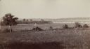
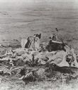
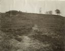
| Date: | 1890 |
|---|---|
| Description: | View of the field where Pickett's charge took place during the Battle of Gettysburg. |
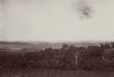
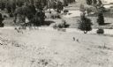
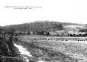
| Date: | 08 1898 |
|---|---|
| Description: | Caption reads: "View from N.E. 1/4 of S.E. 1/4 Sec. 36 L. 12 R 7 W. looking toward Victory, Vernon Co. Wis., showing last 4 miles of trail of Atkinson's Ar... |

| Date: | 1864 |
|---|---|
| Description: | A map of Sherman's March from Atlanta, Georgia to Goldsboro, North Carolina. |
If you didn't find the material you searched for, our Library Reference Staff can help.
Call our reference desk at 608-264-6535 or email us at: