 Filter: Categories of Wisconsin Historical Images
Filter: Subject of Bathing beaches
Filter: Year of 1900-1999
Filter: Categories of Wisconsin Historical Images
Filter: Subject of Bathing beaches
Filter: Year of 1900-1999

| Date: | 06 16 1953 |
|---|---|
| Description: | View of a crowd of people, mostly in swimsuits, at what might be Vilas Beach on Lake Wingra. There is a concession stand in a building in the background. A... |

| Date: | 08 03 1953 |
|---|---|
| Description: | Karen Jeffs of Alberta, Canada, plays in the sand at Vilas Park. |

| Date: | 08 03 1953 |
|---|---|
| Description: | Tom Carroll and his son Alan play in the water at the Vilas Park beach. |

| Date: | 1956 |
|---|---|
| Description: | Intended for tourists, this brochure features a map of Milwaukee's central business district as well as general information about parking, beaches and othe... |

| Date: | 1962 |
|---|---|
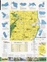
| Description: | This map shows roads, golf courses, ski areas, boat landings, camp sites, waysides, parks, beaches, scenic views, virgin timber tracts, airports, boys and ... |

| Date: | 1920 |
|---|---|
| Description: | View across the water near the shoreline of the municipal swimming pool. The pool may have been along the Wisconsin River with slides and sandy beaches. A ... |
| Date: | 1982 |
|---|---|
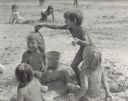
| Description: | A group of four young boys are sitting and standing around a hole dug into the sand and filled with water. One boy is placing the muddy sand onto the head ... |
| Date: | 1982 |
|---|---|
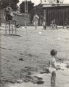
| Description: | Men and women sitting or standing on a sandy beach. A small child is standing on the shoreline in the water. A small group of people is sitting on a grassy... |

| Date: | 1982 |
|---|---|
| Description: | Three young boys playing in a small hole dug into the sand and filled with water. The boy's bodies and swimsuits are covered in muddy sand. |

| Date: | 1962 |
|---|---|
| Description: | This map shows roads, golf courses, ski areas, boat landings, camp sites, waysides, parks, beaches, scenic views, virgin timber tracts, airports, boys and ... |

| Date: | 1938 |
|---|---|
| Description: | This map shows roads, parks, golf courses, airports, beaches, docks and harbors, lighthouses, and buoys within Winnebago County and parts of Waushara, Calu... |

| Date: | 1990 |
|---|---|
| Description: | This map shows various types of trails, boat landings, canoe areas, public beaches, picnic areas, campgrounds, golf courses, public tennis courts, and othe... |

| Date: | 1960 |
|---|---|
| Description: | This map shows public boat ramps, parks, highways, beaches, bluffs, Green Bay, Garrett Bay, Europe Bay and Lake, Rowley's Bay and Ellison Bay. The map incl... |

| Date: | 1970 |
|---|---|
| Description: | This map shows roads, parks, swimming beaches, golf courses, yacht harbors, light houses, airports, public hunting grounds, waysides, schools, and fishing ... |

| Date: | 1959 |
|---|---|
| Description: | This map shows public access sites, public beaches and parks, other public shorelines, boat liveries, public hunting and fishing grounds, railroads, roads,... |

| Date: | 06 26 1927 |
|---|---|
| Description: | A group of three swimmers, two men and one woman, posing on the beach at Lake Calhoun. |
| Date: | 1970 |
|---|---|
| Description: | This map includes illustrations, a location map, text, lakes fishing guide, beaches, harbor and yacht clubs, and bathymetric maps of 10 lakes: Beechwood La... |

| Date: | 1994 |
|---|---|
| Description: | This map shows historical sites, picnic grounds, public boat landings, canoe and motor boat trips, and resort locations. The left margin of the map include... |

| Date: | 1908 |
|---|---|
| Description: | Hand-colored view of Rosenheimer Resort from across Big Cedar Lake. The resort has a large main building with a wrap-around porch, and there is a dock and ... |
| Date: | 1949 |
|---|---|
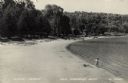
| Description: | View across beach towards a small boy standing at the water's edge. Rowboats are resting on the shoreline in the background. Caption reads: "Sand Beach, Eg... |
If you didn't find the material you searched for, our Library Reference Staff can help.
Call our reference desk at 608-264-6535 or email us at: