 Filter: Categories of Wisconsin Historical Images
Filter: Subject of Banks and banking
Filter: Subject of streets
Filter: Subject of water
Filter: Categories of Wisconsin Historical Images
Filter: Subject of Banks and banking
Filter: Subject of streets
Filter: Subject of water

| Date: | 1896 |
|---|---|
| Description: | Bird's-eye view of Washburn, with twenty vignettes around side, water in foreground with docks and lumber corral. Thirty-three locations identified in key ... |

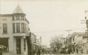
| Date: | |
|---|---|
| Description: | Corner of King, Main, and Pinckney streets looking toward Lake Monona. The Bank of Madison is in the foreground. |
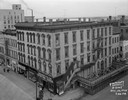
| Date: | 12 10 1948 |
|---|---|
| Description: | Elevated view from the roof of the Park Hotel. Main Street businesses seen include, from the left: Western Union Telegraph Company at 21 West Main Street, ... |

| Date: | 03 21 1949 |
|---|---|
| Description: | Elevated view from the Wisconsin State Capitol, showing Pinckney Street side of the Square, looking down East Washington Avenue. Buildings include the Belm... |

| Date: | 1870 |
|---|---|
| Description: | Elevated view of City Square, where the Bank of Menasha is seen on the corner and Little Lake Butte des Mortes is in the distance. |
| Date: | |
|---|---|
| Description: | Storefronts and pedestrians on Main Street, with Buffalo Lake in the background. The Montello State Bank is on the left street corner. The City Market is f... |

| Date: | 03 1954 |
|---|---|
| Description: | Elevated view from the Wisconsin State Capitol towards Pinckney Street from East Washington to King Street. |
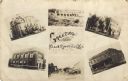
| Date: | |
|---|---|
| Description: | Photographic collage of six views of Black River Falls, featuring the Grade School, High School, Bank, Main Street, a commercial business block and the da... |

| Date: | 1888 |
|---|---|
| Description: | This map has relief shown by hachures and features inset maps of a plat of E.D. Clinton and Blackwell’s add’n to the City of La Crosse. Wards (1-10) shaded... |

| Date: | 1927 |
|---|---|
| Description: | This map includes an index and highways marked in red. Attractions on the map include: Four Mile House, Cold Springs, Grand Crossing Station, Coleman Sloug... |

| Date: | 1929 |
|---|---|
| Description: | This is a blue line print map that shows local streets, railroads, local businesses, schools, parks, cemeteries, the airport, the state capitol, the Univer... |

| Date: | 1969 |
|---|---|
| Description: | This street map was given out by Mound City Bank and features a legend of points of interest and a street index. Streets are labeled as is the Roundtree Br... |

| Date: | 1976 |
|---|---|
| Description: | This map includes an index of streets, government and historic buildings, hospitals, schools, places of recreation, churches, cemeteries, and other miscell... |

| Date: | 1960 |
|---|---|
| Description: | This street map was likely given out by Mound City Bank and features a legend of points of interest and a street index. Streets are labeled as is the Round... |

| Date: | 1883 |
|---|---|
| Description: | This map shows ward boundaries, names of additions, streets, bridges, mills, schools, religious buildings, businesses, hotels, railroads, factories, brewer... |
| Date: | 1980 |
|---|---|
| Description: | Elevated view of East Washington Avenue from the Wisconsin State Capitol. There is a glass bank building on the right side of East Washington Avenue. The Y... |

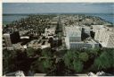
| Date: | 1980 |
|---|---|
| Description: | Aerial view of Capitol Square and the surrounding central isthmus. Lake Monona is on the right. |
If you didn't find the material you searched for, our Library Reference Staff can help.
Call our reference desk at 608-264-6535 or email us at:
