 Filter: Categories of Wisconsin Historical Images
Filter: Subject of Banks and banking
Filter: Subject of roads
Filter: Subject of streets
Filter: Categories of Wisconsin Historical Images
Filter: Subject of Banks and banking
Filter: Subject of roads
Filter: Subject of streets

| Date: | 05 18 1934 |
|---|---|
| Description: | Elevated view of East Washington Avenue taken from an upper level of the Wisconsin State Capitol. Shows the First National Bank Building, American Exchange... |

| Date: | 1896 |
|---|---|
| Description: | Bird's-eye view of Washburn, with twenty vignettes around side, water in foreground with docks and lumber corral. Thirty-three locations identified in key ... |

| Date: | |
|---|---|
| Description: | View across street toward the bank. Near the bank is an automobile, pedestrians and a horse pulling a wagon. |
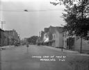
| Date: | 1922 |
|---|---|
| Description: | View down Main Street looking west. On these blocks there is a restaurant, rug store, post office, and Farmers State Bank. Automobiles are parked on both s... |

| Date: | 1976 |
|---|---|
| Description: | Includes index of streets and of local businesses. Shows location of Citizens State Bank, roads, highways, railroads, parks, cemeteries, and city sanitary ... |

| Date: | 1857 |
|---|---|
| Description: | This map shows lot and block numbers, buildings, some land ownership, wards, waterways, streets, railroads, brick yards, and cemeteries. It includes an ind... |
If you didn't find the material you searched for, our Library Reference Staff can help.
Call our reference desk at 608-264-6535 or email us at:
