 Filter: Categories of Wisconsin Historical Images
Filter: Subject of Banks and banking
Filter: Subject of rivers
Filter: Categories of Wisconsin Historical Images
Filter: Subject of Banks and banking
Filter: Subject of rivers
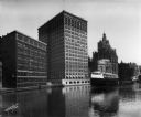
| Date: | 07 13 1915 |
|---|---|
| Description: | Looking south from Wells Street. A boat travels along the Milwaukee River in the foreground. Landmarks left to right: Manufacturers Home Building, First Na... |

| Date: | 08 08 1919 |
|---|---|
| Description: | Elevated view up the Milwaukee River from Wisconsin Avenue bridge. A World War I submarine travels down the Milwaukee River. A crowd is gathered at the riv... |
| Date: | 1928 |
|---|---|
| Description: | An open drawbridge with a boat crossing below. The First National Bank is in the background. |

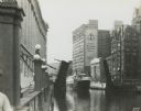
| Date: | 1914 |
|---|---|
| Description: | View of downtown Milwaukee riverbank before the First National Bank was built in 1914. Advertising painted on the sides of buildings includes B. Mock & So... |

| Date: | 07 21 1962 |
|---|---|
| Description: | A parking lot underneath a newly developed block of stores. The Rock River is visible just beyond the parking lot. There is a bridge in the background. |

| Date: | 1923 |
|---|---|
| Description: | This map shows trails, some in red, for automobiles. The right margin includes a key of markings as well as Minnesota and Wisconsin Highway signs. Communit... |
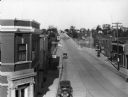
| Date: | 1930 |
|---|---|
| Description: | Elevated view of High Street (Highway 96) and the bridge over the Fox River at Wrightstown. Farmers & Traders Bank is at left, a sign for Meuleman's Elect... |
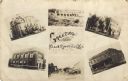
| Date: | |
|---|---|
| Description: | Photographic collage of six views of Black River Falls, featuring the Grade School, High School, Bank, Main Street, a commercial business block and the da... |

| Date: | 1969 |
|---|---|
| Description: | This street map was given out by Mound City Bank and features a legend of points of interest and a street index. Streets are labeled as is the Roundtree Br... |

| Date: | 1960 |
|---|---|
| Description: | This street map was likely given out by Mound City Bank and features a legend of points of interest and a street index. Streets are labeled as is the Round... |

| Date: | 1883 |
|---|---|
| Description: | This map shows ward boundaries, names of additions, streets, bridges, mills, schools, religious buildings, businesses, hotels, railroads, factories, brewer... |
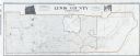
| Date: | 1909 |
|---|---|
| Description: | A map of Lewis County, Washington. There are two photographs at the top, an exterior and interior view of the bank building of Coffman, Dobson, & Co. Banke... |
If you didn't find the material you searched for, our Library Reference Staff can help.
Call our reference desk at 608-264-6535 or email us at: