 Filter: Categories of Wisconsin Historical Images
Filter: Subject of Banks and banking
Filter: Subject of recreation areas
Filter: Subject of parks
Filter: Categories of Wisconsin Historical Images
Filter: Subject of Banks and banking
Filter: Subject of recreation areas
Filter: Subject of parks
| Date: | 1890 |
|---|---|
| Description: | The Madison water tower and farmers' market as seen through the stone gateway at the East Washington Avenue entrance to the Capitol Park. The building on t... |
| Date: | 1940 |
|---|---|
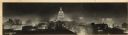
| Description: | Panorama view, elevated, of the Wisconsin State Capitol at night from the roof of a building on Monona Avenue. The First National Bank and the Belmont Hote... |
| Date: | |
|---|---|
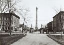
| Description: | A view of the Capitol Park and Pinckney Street taken approximately 1885-1890. The building in the center, at the intersection of Pinckney and East Washingt... |

| Date: | 05 18 1934 |
|---|---|
| Description: | Elevated view of East Washington Avenue taken from an upper level of the Wisconsin State Capitol. Shows the First National Bank Building, American Exchange... |
| Date: | |
|---|---|
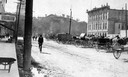
| Description: | View of the North Wing of the third Wisconsin State Capitol in the background, the Capitol Park, and farm wagons on East Washington Avenue on market day. T... |
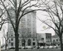
| Date: | 1954 |
|---|---|
| Description: | View from Capitol Park of the First National Bank building and other buildings on Pinckney Street. Cars are parked at an angle on the street. |

| Date: | 1910 |
|---|---|
| Description: | A small crowd watch as eight dogs perform in Capitol Park. There are circus or carnival tents erected along Pinckney Street, and the First National Bank (l... |

| Date: | |
|---|---|
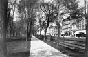
| Description: | Pedestrians walk through a park past a bandstand and trees. The Park Building can be seen behind them, built in 1914. To its right stands Lee Savings Bank. |
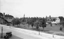
| Date: | 1932 |
|---|---|
| Description: | Elevated view of one automobile parked on Main Street near a park (the Legion Memorial Park), trees, an American flag, street lights, and various buildings... |

| Date: | 1932 |
|---|---|
| Description: | Elevated view of one automobile parked on Main Street. The Legion Memorial Park is across the street. There is a hospital building in the background. Trees... |

| Date: | 1976 |
|---|---|
| Description: | Includes index of streets and of local businesses. Shows location of Citizens State Bank, roads, highways, railroads, parks, cemeteries, and city sanitary ... |

| Date: | 1888 |
|---|---|
| Description: | This map has relief shown by hachures and features inset maps of a plat of E.D. Clinton and Blackwell’s add’n to the City of La Crosse. Wards (1-10) shaded... |

| Date: | 1927 |
|---|---|
| Description: | This map includes an index and highways marked in red. Attractions on the map include: Four Mile House, Cold Springs, Grand Crossing Station, Coleman Sloug... |

| Date: | 1929 |
|---|---|
| Description: | This is a blue line print map that shows local streets, railroads, local businesses, schools, parks, cemeteries, the airport, the state capitol, the Univer... |

| Date: | 1883 |
|---|---|
| Description: | This map shows ward boundaries, names of additions, streets, bridges, mills, schools, religious buildings, businesses, hotels, railroads, factories, brewer... |
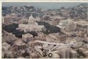
| Date: | 1980 |
|---|---|
| Description: | Aerial view of the Capitol facing Lake Mendota. The Spirit of St. Louis is superimposed on the postcard. Landmarks include the glass bank, the YWCA and Jam... |
If you didn't find the material you searched for, our Library Reference Staff can help.
Call our reference desk at 608-264-6535 or email us at: