 Filter: Categories of Wisconsin Historical Images
Filter: Subject of Banks and banking
Filter: Subject of lakes
Filter: Categories of Wisconsin Historical Images
Filter: Subject of Banks and banking
Filter: Subject of lakes
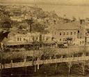
| Date: | 1859 |
|---|---|
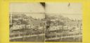
| Description: | South Pinckney Street as photographed by Fuller from the Wisconsin State Capitol roof. In the center are several wooden structures dating from Madison's e... |

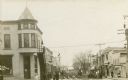
| Date: | |
|---|---|
| Description: | Corner of King, Main, and Pinckney streets looking toward Lake Monona. The Bank of Madison is in the foreground. |
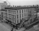
| Date: | 12 10 1948 |
|---|---|
| Description: | Elevated view from the roof of the Park Hotel. Main Street businesses seen include, from the left: Western Union Telegraph Company at 21 West Main Street, ... |

| Date: | 03 21 1949 |
|---|---|
| Description: | Elevated view from the Wisconsin State Capitol, showing Pinckney Street side of the Square, looking down East Washington Avenue. Buildings include the Belm... |
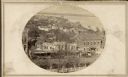
| Date: | 1859 |
|---|---|
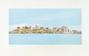
| Description: | Madison's Pinckney Street, with the Capitol Park in the foreground and Farwell's octagon house and Lake Monona in the distance. This view has been various... |

| Date: | 1870 |
|---|---|
| Description: | Elevated view of City Square, where the Bank of Menasha is seen on the corner and Little Lake Butte des Mortes is in the distance. |
| Date: | |
|---|---|
| Description: | Storefronts and pedestrians on Main Street, with Buffalo Lake in the background. The Montello State Bank is on the left street corner. The City Market is f... |
| Date: | 12 11 1970 |
|---|---|
| Description: | Caption on back reads, "Given by 1st National Bank to student customers, 11-XII-70 [12/11/70]. This is the design of their new 'Madisonian' checks." Depi... |

| Date: | 03 1954 |
|---|---|
| Description: | Elevated view from the Wisconsin State Capitol towards Pinckney Street from East Washington to King Street. |
| Date: | |
|---|---|
| Description: | South Wisconsin Avenue and West Main Street. Lake Monona is in the background and the Lucius Fairchild and David Atwood houses are at the upper left. The r... |

| Date: | 1923 |
|---|---|
| Description: | This map shows trails, some in red, for automobiles. The right margin includes a key of markings as well as Minnesota and Wisconsin Highway signs. Communit... |

| Date: | |
|---|---|
| Description: | This map from the early 20th century shows the township and range grid, towns, sections, cities and villages, railroads, roads, schools, churches, and stre... |

| Date: | 1905 |
|---|---|
| Description: | Shows railroads, roads, post offices, creeks, lakes, and cities. Includes chart of deposits and total resources from the years 1890 to 1905. "First Natio... |
| Date: | 1930 |
|---|---|
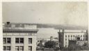
| Description: | Panoramic elevated view to the southeast from the Capitol Square. The Tenney Building appears behind the original first National Bank that was demolished t... |
| Date: | 1930 |
|---|---|
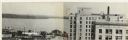
| Description: | Elevated view to the south from the Capitol Square. The large building on the left is the original first National Bank that was demolished to make way for ... |

| Date: | 1929 |
|---|---|
| Description: | This is a blue line print map that shows local streets, railroads, local businesses, schools, parks, cemeteries, the airport, the state capitol, the Univer... |
| Date: | 1980 |
|---|---|
| Description: | Elevated view of East Washington Avenue from the Wisconsin State Capitol. There is a glass bank building on the right side of East Washington Avenue. The Y... |

| Date: | 1980 |
|---|---|
| Description: | Aerial view of Capitol Square and the surrounding central isthmus. Lake Monona is on the right. |
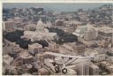
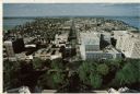
| Date: | 1980 |
|---|---|
| Description: | Aerial view of the Capitol facing Lake Mendota. The Spirit of St. Louis is superimposed on the postcard. Landmarks include the glass bank, the YWCA and Jam... |
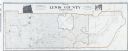
| Date: | 1909 |
|---|---|
| Description: | A map of Lewis County, Washington. There are two photographs at the top, an exterior and interior view of the bank building of Coffman, Dobson, & Co. Banke... |
If you didn't find the material you searched for, our Library Reference Staff can help.
Call our reference desk at 608-264-6535 or email us at: