 Filter: Categories of Wisconsin Historical Images
Filter: Subject of Banks and banking
Filter: Subject of education
Filter: Year of 1900-1999
Filter: Categories of Wisconsin Historical Images
Filter: Subject of Banks and banking
Filter: Subject of education
Filter: Year of 1900-1999
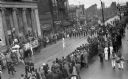
| Date: | 1935 |
|---|---|
| Description: | Elevated view of students in a school marching band in a parade marching down Main Street. Students are wearing marching band uniforms and are playing inst... |

| Date: | 1927 |
|---|---|
| Description: | This map includes an index and highways marked in red. Attractions on the map include: Four Mile House, Cold Springs, Grand Crossing Station, Coleman Sloug... |

| Date: | 1929 |
|---|---|
| Description: | This is a blue line print map that shows local streets, railroads, local businesses, schools, parks, cemeteries, the airport, the state capitol, the Univer... |

| Date: | 1976 |
|---|---|
| Description: | This map includes an index of streets, government and historic buildings, hospitals, schools, places of recreation, churches, cemeteries, and other miscell... |

| Date: | 1980 |
|---|---|
| Description: | Aerial view of Capitol Square and the surrounding central isthmus. Lake Monona is on the right. |

| Date: | 11 15 1960 |
|---|---|
| Description: | New third grade Sun Prairie teacher Diane Schnitt meets banker Tom Tubbs and mayor Joseph N. Hanley. |
If you didn't find the material you searched for, our Library Reference Staff can help.
Call our reference desk at 608-264-6535 or email us at:
