 Filter: Categories of Wisconsin Historical Images
Filter: Subject of Banks and banking
Filter: Subject of church buildings
Filter: Categories of Wisconsin Historical Images
Filter: Subject of Banks and banking
Filter: Subject of church buildings
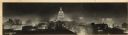
| Date: | 1940 |
|---|---|
| Description: | Panorama view, elevated, of the Wisconsin State Capitol at night from the roof of a building on Monona Avenue. The First National Bank and the Belmont Hote... |

| Date: | 1896 |
|---|---|
| Description: | Bird's-eye view of Washburn, with twenty vignettes around side, water in foreground with docks and lumber corral. Thirty-three locations identified in key ... |
| Date: | 12 11 1970 |
|---|---|
| Description: | Caption on back reads, "Given by 1st National Bank to student customers, 11-XII-70 [12/11/70]. This is the design of their new 'Madisonian' checks." Depi... |
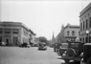
| Date: | 1930 |
|---|---|
| Description: | View down street of cars and trucks parked along Third Street in this view looking East across Oak Street. The First National Bank, left, is diagonally acr... |
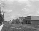
| Date: | |
|---|---|
| Description: | View across Main Street, with a clothing store, livery stable, bank, and church on the right. A group of young men and boys stand on the sidewalk wearing s... |

| Date: | |
|---|---|
| Description: | This map from the early 20th century shows the township and range grid, towns, sections, cities and villages, railroads, roads, schools, churches, and stre... |
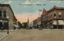
| Date: | 1917 |
|---|---|
| Description: | Colorized postcard view of the central business district. The street is lined with businesses and street lamps. A man and a dog are in front of the bank on... |

| Date: | 1888 |
|---|---|
| Description: | This map has relief shown by hachures and features inset maps of a plat of E.D. Clinton and Blackwell’s add’n to the City of La Crosse. Wards (1-10) shaded... |

| Date: | 1927 |
|---|---|
| Description: | This map includes an index and highways marked in red. Attractions on the map include: Four Mile House, Cold Springs, Grand Crossing Station, Coleman Sloug... |

| Date: | 1929 |
|---|---|
| Description: | This is a blue line print map that shows local streets, railroads, local businesses, schools, parks, cemeteries, the airport, the state capitol, the Univer... |

| Date: | 1976 |
|---|---|
| Description: | This map includes an index of streets, government and historic buildings, hospitals, schools, places of recreation, churches, cemeteries, and other miscell... |

| Date: | 1883 |
|---|---|
| Description: | This map shows ward boundaries, names of additions, streets, bridges, mills, schools, religious buildings, businesses, hotels, railroads, factories, brewer... |

| Date: | 1857 |
|---|---|
| Description: | This map shows lot and block numbers, buildings, some land ownership, wards, waterways, streets, railroads, brick yards, and cemeteries. It includes an ind... |
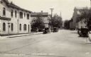
| Date: | |
|---|---|
| Description: | View looking up Columbia Avenue, with the Merchants Bank on the left, and a mill, and a church further down on the right. Automobiles are parked along the ... |
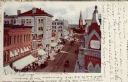
| Date: | 1906 |
|---|---|
| Description: | Hand-colored, elevated view of Main Street, with a bank in the foreground on the right, and a church in the distance. Caption reads: "Main Street, La Cross... |
If you didn't find the material you searched for, our Library Reference Staff can help.
Call our reference desk at 608-264-6535 or email us at:
