 Filter: Categories of Wisconsin Historical Images
Filter: Subject of Banks and banking
Filter: Community of La Crosse
Filter: Subject of human settlements
Filter: Categories of Wisconsin Historical Images
Filter: Subject of Banks and banking
Filter: Community of La Crosse
Filter: Subject of human settlements

| Date: | 1888 |
|---|---|
| Description: | This map has relief shown by hachures and features inset maps of a plat of E.D. Clinton and Blackwell’s add’n to the City of La Crosse. Wards (1-10) shaded... |

| Date: | 1927 |
|---|---|
| Description: | This map includes an index and highways marked in red. Attractions on the map include: Four Mile House, Cold Springs, Grand Crossing Station, Coleman Sloug... |

| Date: | 1883 |
|---|---|
| Description: | This map shows ward boundaries, names of additions, streets, bridges, mills, schools, religious buildings, businesses, hotels, railroads, factories, brewer... |
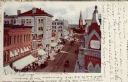
| Date: | 1906 |
|---|---|
| Description: | Hand-colored, elevated view of Main Street, with a bank in the foreground on the right, and a church in the distance. Caption reads: "Main Street, La Cross... |
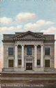
| Date: | |
|---|---|
| Description: | Photochrome view of the columned facade of the National Bank. Caption reads: "The National Bank of La Crosse, La Crosse, Wis." |
If you didn't find the material you searched for, our Library Reference Staff can help.
Call our reference desk at 608-264-6535 or email us at: