 Filter: Categories of Wisconsin Historical Images
Filter: Subject of Automobiles
Filter: Subject of maps
Filter: Categories of Wisconsin Historical Images
Filter: Subject of Automobiles
Filter: Subject of maps
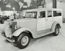
| Date: | 05 31 1934 |
|---|---|
| Description: | An International paneled station wagon ("woody") on display in the International Harvester exhibit at the "A Century of Progress" world's fair. |

| Date: | 1930 |
|---|---|
| Description: | Exterior view of the Triangle filling station on Highway 12, which sold gasoline, ice, and other items. A man stands in front by the gas pump, and a map of... |
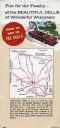
| Date: | |
|---|---|
| Description: | Back fold of a Wisconsin Dells promotional brochure featuring a simplified Wisconsin highway map with directions to the Dells, and a drawing of a family dr... |
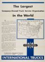
| Date: | 1931 |
|---|---|
| Description: | Poster advertising International Trucks as "The Largest Company-Owned Truck Service in the World." The poster features a United States map listing Internat... |
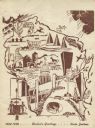
| Date: | 1948 |
|---|---|
| Description: | Holiday card of the history of the State of Wisconsin, 1848-1948. Shows a map of Wisconsin with many historical and themed elements. Image was created by w... |
| Date: | |
|---|---|
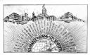
| Description: | Promotional postcard with three city scene sketches and thirty-one characteristics of the city listed. Caption reads: "Kankakee the Rising City Beautiful." |

| Date: | 1943 |
|---|---|
| Description: | View across road of Day's Service Station with gasoline pumps, maps and signs out front. The right half of the building is one-story high, and the left hal... |

| Date: | 1924 |
|---|---|
| Description: | This map shows railroads, electric lines, and steamship lines. The left margin includes an index of principal cities, and the lower left corner includes a... |

| Date: | 1920 |
|---|---|
| Description: | This map shows the entire state as well as portions of Iowa, Illinois, Minnesota, and Michigan. Counties outlined in yellow, cities, rivers, lakes, and rai... |

| Date: | 1920 |
|---|---|
| Description: | The map shows the entire state with cities, rivers, and lakes labeled. The upper and right margin include inset maps of Racine, Milwaukee, Waukesha, Applet... |
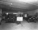
| Date: | 03 26 1929 |
|---|---|
| Description: | "Truck That Crossed The Sahara" is on display in a dealership. In the foreground is a map on an easel. |
If you didn't find the material you searched for, our Library Reference Staff can help.
Call our reference desk at 608-264-6535 or email us at: