 Filter: Categories of Wisconsin Historical Images
Filter: Subject of Automobiles
Filter: Type of Map or Atlas
Filter: Year of 1900-1999
Filter: Creator Name of Unknown
Filter: Categories of Wisconsin Historical Images
Filter: Subject of Automobiles
Filter: Type of Map or Atlas
Filter: Year of 1900-1999
Filter: Creator Name of Unknown

| Date: | 1920 |
|---|---|
| Description: | A two-sided map of the state of Wisconsin. The front includes towns and major cities as well as state and county trunk highways. The back includes a smalle... |
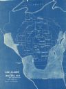
| Date: | 1928 |
|---|---|
| Description: | This blue line map shows the number of carload shipments to northern and central counties, with Mosinee being the central distribution point. Lake Michigan... |
If you didn't find the material you searched for, our Library Reference Staff can help.
Call our reference desk at 608-264-6535 or email us at: