 Filter: Categories of Wisconsin Historical Images
Filter: Subject of Automobile driving
Filter: Subject of botany
Filter: Year of 1900-1999
Filter: Year of 1930-1939
Filter: Categories of Wisconsin Historical Images
Filter: Subject of Automobile driving
Filter: Subject of botany
Filter: Year of 1900-1999
Filter: Year of 1930-1939
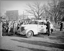
| Date: | 10 27 1938 |
|---|---|
| Description: | AAA driver's training instructor with group of students, posing with dual control driver's education car, in front of Madison East High School. |
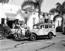
| Date: | 08 11 1936 |
|---|---|
| Description: | Four-man crew demonstrating their filming techniques with an International C-1 wood-paneled ("woody") station wagon in front of Metropolitan Studios. The c... |
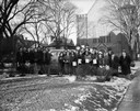
| Date: | 02 18 1939 |
|---|---|
| Description: | Group portrait of Central High School driving license class holding certificates and standing beside "AAA Dual Control Driver Training Car." They are stand... |
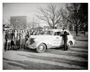
| Date: | 10 27 1938 |
|---|---|
| Description: | AAA dual-control training car parked at East High School, 2222 East Washington Avenue. Several students are in the car, a Pontiac, with a man standing next... |
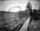
| Date: | 09 27 1930 |
|---|---|
| Description: | The corner of State Street and Capitol Square from the roof of the Leath Furniture Store, with a view of the 100 block of State Street, the Wisconsin State... |

| Date: | 1930 |
|---|---|
| Description: | Pictorial map of Glacier National Park, Montana and Waterton Lakes National Park, Alberta. Illustrated by Joe Scheurle, it depicts white people, American ... |
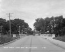
| Date: | 1930 |
|---|---|
| Description: | View down middle of road of car driving across a bridge over Sugar River. Another car is parked by the Wisconsin Power and Light Company. |
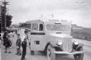
| Date: | 1930 |
|---|---|
| Description: | View down side of road of a group of children exiting an International school bus. On the front and side of the bus is painted the "International" emblem. ... |

| Date: | 1930 |
|---|---|
| Description: | This map shows the entire state plus portions of Illinois, Iowa, Minnesota, and Michigan outlined in blue. The map shows roads, state parks (black triangle... |
If you didn't find the material you searched for, our Library Reference Staff can help.
Call our reference desk at 608-264-6535 or email us at: