 Filter: Categories of Wisconsin Historical Images
Filter: Subject of Architecture
Filter: Subject of prairies
Filter: Categories of Wisconsin Historical Images
Filter: Subject of Architecture
Filter: Subject of prairies

| Date: | 1848 |
|---|---|
| Description: | Wisconsin became the thirtieth state in 1848. Drawn that same year, this map shows township lines, roads, villages, mills, railroads, prairies, swamps, can... |
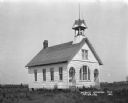
| Date: | 1921 |
|---|---|
| Description: | Exterior of the public schoolhouse, which features a bell tower and two arched entrances. |

| Date: | 1925 |
|---|---|
| Description: | Elevated view of Mount Vernon from the a grassy hill. |

| Date: | 1858 |
|---|---|
| Description: | An ink on paper map of Milwaukee County and the eastern portion of Waukesha County that shows the townships of Oak Creek, Franklin, Greenfield, Wauwatosa, ... |

| Date: | 1873 |
|---|---|
| Description: | This map shows lots and blocks, additions and subdivisions, and large-scale landownership. The map is oriented with north to the upper right. The map is fr... |

| Date: | 1832 |
|---|---|
| Description: | This map shows lot and block numbers, as well as the location of a shot tower, houses, stores, and barns. The map is oriented with the north to the left. T... |
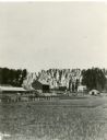
| Date: | 1886 |
|---|---|
| Description: | View across field towards a farm, with farmhouse, barn, outbuildings, and fences. The photograph appeared in Joseph Schafer's 1932 book The Wisconsin Le... |
If you didn't find the material you searched for, our Library Reference Staff can help.
Call our reference desk at 608-264-6535 or email us at:
