 Filter: Categories of Wisconsin Historical Images
Filter: Subject of Architecture
Filter: Subject of mounds
Filter: Categories of Wisconsin Historical Images
Filter: Subject of Architecture
Filter: Subject of mounds
| Date: | |
|---|---|
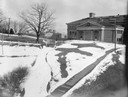
| Description: | A turtle effigy mound on the University of Wisconsin-Madison campus, outlined by melting snow. |
| Date: | |
|---|---|
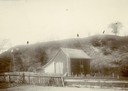
| Description: | View of large platform mound with small barn in the foreground. The numbers 1, 2, and 3 are written on the photograph in ink. |
| Date: | |
|---|---|
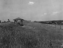
| Description: | Pavilion in the park is on left, with a fence along the right. |
| Date: | 1935 |
|---|---|
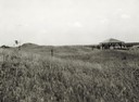
| Description: | View of the site when it was known as Aztalan Mound Park or Aztalan Mounds, near Lake Mills. There is a pavilion in the right background. |
| Date: | 1910 |
|---|---|
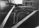
| Description: | Elevated view of a double-tailed turtle effigy mound on Observatory Hill on the University of Wisconsin-Madison campus. |
| Date: | |
|---|---|
| Description: | A view of a two-tailed water spirit burial mound on the grounds of the University of Wisconsin-Madison campus near Observatory Hill. |

| Date: | 1908 |
|---|---|
| Description: | Children posing on a conical burial mound at Merrill Springs, on the south shore of Lake Mendota. (Also known as Merrill's Spring.) |

| Date: | 1859 |
|---|---|
| Description: | Map featuring various views of buildings and scenes from Sauk County. |

| Date: | |
|---|---|
| Description: | Wisconsin Memorial Hospital with a key to buildings in the upper left. Indian mounds are marked on the site. Arthur Peabody was the state architect for th... |
| Date: | |
|---|---|
| Description: | Elevated view of Man Mound outlined in chalk looking south. A road bisects the legs of the effigy mound. A small outbuilding can be seen at left in the for... |

| Date: | 1927 |
|---|---|
| Description: | Blueprint-style map of Frost Woods on the shore of Lake Monona. The map indicates the locations of Indian mounds, an Indian camp, and various plants. There... |

| Date: | 1839 |
|---|---|
| Description: | A chart showing the geological cross-section and the height above the surrounding landscape of several locations, such as Platte Mound in Wisconsin, and th... |

| Date: | 1970 |
|---|---|
| Description: | This pictorial map of Dunn County, Wisconsin, from the 1970s depicts historical events that occurred in the county. It shows cemeteries, churches, schools,... |

| Date: | 1859 |
|---|---|
| Description: | Shows townships and sections, landownership, roads, railroads, rural residences, schools, churches, and topography. Relief shown by hachures. "From governm... |

| Date: | |
|---|---|
| Description: | Photographic postcard view of one of the Indian mounds at Aztalan State Park. Steps lead up to the top of the mound from the right, and a tall fence is beh... |

| Date: | 1933 |
|---|---|
| Description: | Blue print and blue line print maps that show local streets, Nakoma Country Club, part of Lake Forest, and part of Lake Wingra. A legend is included that s... |

| Date: | |
|---|---|
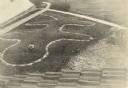
| Description: | View looking uphill towards three platform mounds. The numbers 1, 2, and 3 are written on the photograph in ink. Part of the way up the hill are a small sh... |

| Date: | 1900 |
|---|---|
| Description: | This photocopy map shows marshes, woods, buildings, and selected features including islands, mounds, old Fort Crawford, and "new site for a fort in questio... |

| Date: | 06 2008 |
|---|---|
| Description: | View looking east of a 1000-year-old Indian intaglio effigy in the shape of a panther. The effigy, which is on the north bank of the Rock River, is filled ... |

| Date: | 01 12 2016 |
|---|---|
| Description: | Protesters gathering at the Save the Mounds demonstration around the Capitol Square against Assembly Bill 620. A protest sign is attached to the statue "Fo... |
If you didn't find the material you searched for, our Library Reference Staff can help.
Call our reference desk at 608-264-6535 or email us at: