 Filter: Categories of Wisconsin Historical Images
Filter: Subject of Architecture
Filter: Subject of great lakes
Filter: Categories of Wisconsin Historical Images
Filter: Subject of Architecture
Filter: Subject of great lakes

| Date: | 07 04 1931 |
|---|---|
| Description: | Inside of Saturday dinner menu for the "North American." Includes drawings of Niagara Falls, New York, Old Fort Mackinac Island, Michigan, Michigan Bouleva... |

| Date: | 1928 |
|---|---|
| Description: | Inside of Tuesday luncheon menu for the "South American." Includes drawings of Niagara Falls, New York, Old Fort Mackinac Island, Michigan, Michigan Boulev... |

| Date: | 1886 |
|---|---|
| Description: | Bird's-eye view of Bayfield, county seat of Bayfield County. On the lower left side is an inset for Bayfield and the Apostle Islands. |
| Date: | |
|---|---|
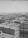
| Description: | Milwaukee, towards South Point from Mitchell Block, E. Water Street and Michigan Street. Elevated view shows buildings and rooftops with bay and harbor in ... |
| Date: | |
|---|---|
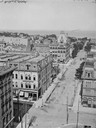
| Description: | Looking east from Mitchell Block. Elevated view of buildings with the lake and a steamship in the distance. |

| Date: | 1883 |
|---|---|
| Description: | Bird's-eye map of Superior, county seat of Douglas County, on the shores of Lake Superior, with insets of points of interest. |

| Date: | 1879 |
|---|---|
| Description: | Bird's-eye map of Two Rivers. |

| Date: | 1896 |
|---|---|
| Description: | Bird's-eye view of Washburn, with twenty vignettes around side, water in foreground with docks and lumber corral. Thirty-three locations identified in key ... |

| Date: | 1910 |
|---|---|
| Description: | Bird's-eye view looking east, with Washburn Harbor at center and Chequamegon Bay in Lake Superior covering most of the upper image. Streets with buildings... |

| Date: | 1892 |
|---|---|
| Description: | Bird's-eye view of the Columbian Exposition pavilions from the vantage point of Lake Michigan. Included is an inset of the Union Passenger Station (now Uni... |
| Date: | 1907 |
|---|---|
| Description: | View from water of beach and buildings in Ephraim. Caption reads: "Greetings from Ephraim, Wis." |
| Date: | |
|---|---|
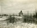
| Description: | Exterior view of the "Pottawatomie" lighthouse in snowy expanse of land, with the lake in the background. |

| Date: | 1835 |
|---|---|
| Description: | Map reads: "Map of the United States of America with its Territories and Districts - Including also a part of Upper and Lower Canada and Mexico". The map i... |
| Date: | |
|---|---|
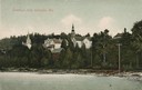
| Description: | Hand-colored view of the Thordarson estate including the boathouse and a stone-paved path with benches. |
| Date: | |
|---|---|
| Description: | The stairs and dock at the lighthouse on Rock Island. |

| Date: | |
|---|---|
| Description: | View from shoreline of boats docked at the fishing wharf. People are fishing from the pier, and a group of people are in a rowboat near a ferry. There are ... |
| Date: | |
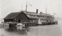
|---|---|
| Description: | View across water towards a large ferry docked at the fishing wharf. A large group of people are standing on the pier, and passengers are standing at the r... |

| Date: | 1887 |
|---|---|
| Description: | The bay shore of Menominee filled with driftwood. |

| Date: | 1891 |
|---|---|
| Description: | Color illustration of the grounds and buildings of the 1893 World's Fair or Columbian Exposition. |

| Date: | 1853 |
|---|---|
| Description: | Wisconsin counties by color and shows railroads, common roads, canals, the state capital, county towns, townships, villages, and post offices, |
If you didn't find the material you searched for, our Library Reference Staff can help.
Call our reference desk at 608-264-6535 or email us at: