 Filter: Categories of Wisconsin Historical Images
Filter: Subject of Architecture
Filter: Creator Name of Milwaukee Lithographing & Engraving Co.
Filter: Categories of Wisconsin Historical Images
Filter: Subject of Architecture
Filter: Creator Name of Milwaukee Lithographing & Engraving Co.
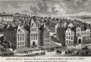
| Date: | 1887 |
|---|---|
| Description: | Engraving of an elevated view of Science Hall, Chemical Laboratory and Machine Shop on the University of Wisconsin-Madison campus. |
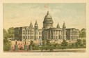
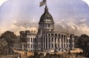
| Date: | 1891 |
|---|---|
| Description: | Chromolithograph of the third Wisconsin State Capitol with a U.S. flag atop the dome. The colored illustration was produced by the Milwaukee Lithography an... |
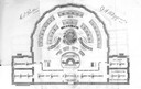
| Date: | 1874 |
|---|---|
| Description: | Seating chart for the Wisconsin Senate as it appeared in the 1874 Legislative Manual, commonly called the Wisconsin Blue Book. |
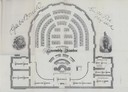
| Date: | 1874 |
|---|---|
| Description: | Seating chart for members of the Wisconsin Assembly as published in the 1874 Legislative Manual, the Wisconsin Blue Book. |
| Date: | 1870 |
|---|---|
| Description: | The third Wisconsin Capitol (the second in Madison) as it appeared shortly after the construction was completed. |
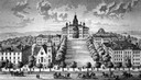
| Date: | 1885 |
|---|---|
| Description: | A view of what is now known as Bascom Hill including Main Hall (Bascom Hall), North Hall, Music Hall, Science Hall, South Hall, Washburn Observatory and Wo... |
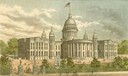
| Date: | 1887 |
|---|---|
| Description: | View of the third Wisconsin State Capitol from the pages of the Wisconsin Blue Book. |
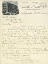
| Date: | 1883 |
|---|---|
| Description: | Engraved letterhead of the firm of Smith, Mendel & Co., a wholesale grocery merchant. William E. Smith was a prominent Milwaukee businessman, partner in th... |
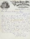
| Date: | 1876 |
|---|---|
| Description: | Letterhead of the Berlin Woolen Mills bearing an engraving of the factory, which is unusual because of its French Mansard roof. |

| Date: | 1896 |
|---|---|
| Description: | This 1896 map shows the township and range system, sections, cities and villages, railroads, roads, vacant land and land sold by the Wisconsin Central Rail... |

| Date: | 1900 |
|---|---|
| Description: | This 1900 map shows the township and range system, sections, cities and villages, railroads, roads, vacant land and land sold by the Wisconsin Central Rail... |
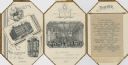
| Date: | 06 05 1884 |
|---|---|
| Description: | Die cut elongated octagonal menu for the 7th annual banquet of the Merchants Association at The Plankinton. On the cover is an oval portrait of a deer with... |
If you didn't find the material you searched for, our Library Reference Staff can help.
Call our reference desk at 608-264-6535 or email us at: