 Filter: Categories of Wisconsin Historical Images
Filter: Subject of Architecture
Filter: Creator Name of C.N. Caspar Company
Filter: Categories of Wisconsin Historical Images
Filter: Subject of Architecture
Filter: Creator Name of C.N. Caspar Company
| Date: | |
|---|---|
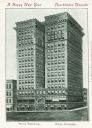
| Description: | View of building. Text in English and German reads: "A Happy New Year" and "Glueckliches Neujahr." Caption at bottom reads: "The Wells Building." and "Well... |
| Date: | |
|---|---|
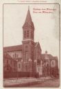
| Description: | N. Fourth Street. Bell tower with clock to the left of the main entrance. Additional buildings are on either side of the main church. Identified on left is... |

| Date: | 1886 |
|---|---|
| Description: | A hand-colored map of Milwaukee County, Wisconsin that shows the township and range system, sections, towns, roads, railroads and rail stations, cities and... |

| Date: | 1891 |
|---|---|
| Description: | A hand-colored map of Milwaukee County, Wisconsin that shows the township and range system, sections, towns, roads, railroads and rail stations, cities and... |

| Date: | 1902 |
|---|---|
| Description: | A map of Milwaukee County, Wisconsin that shows the township and range system, sections, towns, roads, railroads and rail stations, cities and villages, po... |
| Date: | |
|---|---|
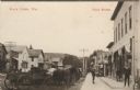
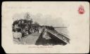
| Description: | Photographic postcard view down sidewalk in a central business district. In the foreground on the left horses and wagons are hitched up at the curb. A smal... |

| Date: | 1904 |
|---|---|
| Description: | This map has three inset maps of Whitefish Bay, Cudahy, and South Milwaukee. This map depicts schools, engine houses, railroads, street railways, city ward... |

| Date: | 1911 |
|---|---|
| Description: | This map shows ward numbers, streets, railroads, electric car lines, parks, steam railways, section numbers, Lake Michigan and one mile concentric circles ... |

| Date: | 1912 |
|---|---|
| Description: | This map shows ward numbers, streets, railroads, electric car lines, parks, steam railways, section numbers, Lake Michigan and one mile concentric circles ... |

| Date: | 1909 |
|---|---|
| Description: | Black and white printed postcard of a drawing of St. Paul's University Chapel, 723 State Street. Caption reads: "St. Paul's University Chapel, (in course o... |
| Date: | 1907 |
|---|---|
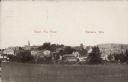
| Description: | Text on front reads: "Bird's Eye View. Theresa, Wis." Elevated view of the town from a field. Homes, farms, businesses and churches can be seen with hills ... |

| Date: | 08 24 1908 |
|---|---|
| Description: | Text on front reads: "Lefebre [sic] Bros. Co.'s Store. Wauwatosa, Wis." A two story, brick building with a parapet and large display windows with transoms ... |
| Date: | 01 03 1901 |
|---|---|
| Description: | Text on front reads: "Glückliches Neues Jahr [Happy New Year]. Whitefish Bay Summer Resort." A crowd of people are enjoying the grounds and view at a resor... |
If you didn't find the material you searched for, our Library Reference Staff can help.
Call our reference desk at 608-264-6535 or email us at: