 Filter: Categories of Wisconsin Historical Images
Filter: Subject of Architecture
Filter: Type of Map or Atlas
Filter: Categories of Wisconsin Historical Images
Filter: Subject of Architecture
Filter: Type of Map or Atlas

| Date: | 04 1945 |
|---|---|
| Description: | Planting plan for Glenwood Children's Park, designed by Jens Jensen. Graphite pencil and colored pencil on tissue (overlays pencil plan) Original drawing... |
| Date: | |
|---|---|
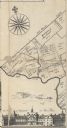
| Description: | A detail of Philadelphia, including Mills Creek, Alms House and land ownership designations. |

| Date: | 1913 |
|---|---|
| Description: | A wall atlas of Sauk County, Wisconsin, displaying its 22 towns. On the left side are advertisements for local businesses. |

| Date: | 1883 |
|---|---|
| Description: | Bird's-eye view of Montello, county seat of Marquette County. The granite quarry, woolen mill, and planing mill are clearly identified. A steamboat on Buf... |
| Date: | 1862 |
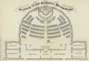
|---|---|
| Description: | Diagram and seating chart for the Wisconsin State Assembly. |

| Date: | 1927 |
|---|---|
| Description: | Blueprint-style map of Frost Woods on the shore of Lake Monona. The map indicates the locations of Indian mounds, an Indian camp, and various plants. There... |

| Date: | 1861 |
|---|---|
| Description: | Shows townships and sections, landowners, and woodlands. Includes inset maps of Monroe, Brodhead, Albany, Cadiz, Decatur, Dayton, Clarence, Springfield, Tw... |

| Date: | 1839 |
|---|---|
| Description: | A chart showing the geological cross-section and the height above the surrounding landscape of several locations, such as Platte Mound in Wisconsin, and th... |

| Date: | 1896 |
|---|---|
| Description: | This hand-colored map shows counties, county seats, cities, towns, proposed and completed railroads, and U.S. Land Offices. Also included in the map are th... |

| Date: | 1897 |
|---|---|
| Description: | A map of Wisconsin showing the self-supporting churches, Home Missionary churches, stations not organized, Sunday schools of C.S.S. Society, Congregational... |

| Date: | 1941 |
|---|---|
| Description: | A map of the area south of Ripon and Sheboygan and east of Waterloo and Janesville, showing the route of the Chicago, North Shore and Milwaukee Railroad in... |

| Date: | 1943 |
|---|---|
| Description: | A map that shows the lands for sale by the Tomahawk Land Company of Tomahawk, Wisconsin, in the counties of Langlade, Lincoln, Oneida, and Price. The map s... |

| Date: | 1853 |
|---|---|
| Description: | Wisconsin counties by color and shows railroads, common roads, canals, the state capital, county towns, townships, villages, and post offices, |

| Date: | 1854 |
|---|---|
| Description: | Map of the whole state Wisconsin includes an inset of the vicinity of Milwaukee, which shows the boundaries for Lisbon, Menomonee, Pewaukee, Brookfield, Wa... |

| Date: | |
|---|---|
| Description: | This detailed map shows fortifications, headquarters, location and dates of battles, street outline of Atlanta, roads, railroads, vegetation, drainage, rel... |

| Date: | 1880 |
|---|---|
| Description: | A hand-colored map of the Chippewa, Price, Taylor and the northern part of Clark counties, which shows the locations of farmhouses, schoolhouses, churches,... |

| Date: | 1880 |
|---|---|
| Description: | Map of Wisconsin including the eastern portions on Minnesota, Iowa, northern Illinois, and the western most portion of Michigan’s Upper Peninsula, showing ... |

| Date: | 1792 |
|---|---|
| Description: | Map of Washington D.C. Labeled on the map are all the main streets, the site of the Capitol and the President's House. The map also shows the relationship ... |

| Date: | 1848 |
|---|---|
| Description: | Wisconsin became the thirtieth state in 1848. Drawn that same year, this map shows township lines, roads, villages, mills, railroads, prairies, swamps, can... |

| Date: | 1931 |
|---|---|
| Description: | This U.S. Geological Survey map of Wisconsin shows counties, cities and villages, lighthouses, Indian reservations, military reservations, and bird and gam... |
If you didn't find the material you searched for, our Library Reference Staff can help.
Call our reference desk at 608-264-6535 or email us at: