 Filter: Categories of Wisconsin Historical Images
Filter: Subject of Archaeology
Filter: Type of Print
Filter: Categories of Wisconsin Historical Images
Filter: Subject of Archaeology
Filter: Type of Print

| Date: | 1851 |
|---|---|
| Description: | Diagram of an effigy mound in the shape of a cross. |

| Date: | 1851 |
|---|---|
| Description: | Map of a portion of Merton including the Bark River, a mill, Fort Hill, and Indian mounds. |
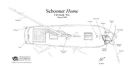
| Date: | 08 2008 |
|---|---|
| Description: | Archaeological overhead view site plan of the remains of the schooner Home. Labels indicate various parts of the ship that remain. At the bottom rig... |
| Date: | 08 2009 |
|---|---|
| Description: | Archaeological overhead view site plan of the schooner Northerner. Labels indicate various parts of the ship that remain. On the left is a map scale... |

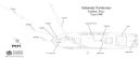
| Date: | |
|---|---|
| Description: | Archaeological overhead view site plan of the schooner Pathfinder. Labels indicate various parts of the ship that remain, showing how much of the sh... |

| Date: | 08 2006 |
|---|---|
| Description: | Archaeological site plan of the schooner Rouse Simmons. The wreck is drawn in great detail, showing the damage to the deck, along with the broken ma... |
| Date: | |
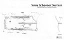
|---|---|
| Description: | Archaeological overhead view site plan of the scow schooner Success. Labels indicate various parts of the ship that remain and how much of the wreck... |
If you didn't find the material you searched for, our Library Reference Staff can help.
Call our reference desk at 608-264-6535 or email us at: