 Filter: Categories of Wisconsin Historical Images
Filter: Subject of Archaeological sites
Filter: Subject of land use
Filter: Categories of Wisconsin Historical Images
Filter: Subject of Archaeological sites
Filter: Subject of land use
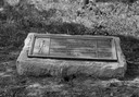
| Date: | 1920 |
|---|---|
| Description: | Historic site marker to commemorate Man Mound and to mark Man Mound Park. The inscription reads "Man Mound Park. Mound located and platted by W.H. Canfield... |
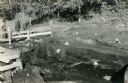
| Date: | 1936 |
|---|---|
| Description: | Three men looking over the process of uncovering bones of a bison in Interstate Park. |
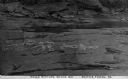
| Date: | |
|---|---|
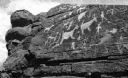
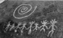
| Description: | An elevated view of Native American picture rocks, also known as petroglyphs. Caption reads: "Indian Picture Rocks No. 1. Smith's Ferry, PA." |
| Date: | |
|---|---|
| Description: | An elevated view of Native American picture rocks, also known as petroglyphs. Caption reads: "Indian Picture Rocks No. 2. Smith's Ferry, PA." |
| Date: | |
|---|---|
| Description: | An elevated view of Native American picture rocks, also known as petroglyphs. Caption reads: "Indian Picture Rocks No. 3. Smith's Ferry, PA." |
| Date: | |
|---|---|
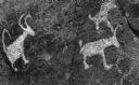
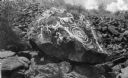
| Description: | A view of Native American petroglyph rock carvings near Tucson. |
| Date: | |
|---|---|
| Description: | Native American petroglyph rock carvings near Tucson. |
| Date: | |
|---|---|
| Description: | Native American petroglyph rock carving near Tucson. |
| Date: | |
|---|---|
| Description: | A view of Native American petroglyph rock engravings near Tucson. |
| Date: | 02 26 1931 |
|---|---|
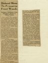
| Description: | Newspaper clipping of an article about the end of Lake Monona Wild Life Sanctuary Association, a group that had been trying to preserve Frost's Woods. |
| Date: | 06 30 1907 |
|---|---|
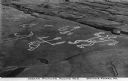
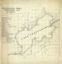
| Description: | Map is ink on tracing paper. The left margin has an index of archeological sites around Koshkonong Lake. Lake Koshkonong is labelled. |

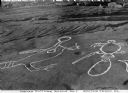
| Date: | 07 13 1918 |
|---|---|
| Description: | View of the excavation of two graves located on University Hill (now Bascom Hill). Main Hall (now Bascom Hall) can be seen in the background. |

| Date: | 01 1969 |
|---|---|
| Description: | A map of Oneida county, which includes a small drawing of a hodag. |

| Date: | 1924 |
|---|---|
| Description: | A map of the Madison Township, T7N R9E including Lake Mendota showing the location of Ho Chunk encampments and effigy mounds. |
If you didn't find the material you searched for, our Library Reference Staff can help.
Call our reference desk at 608-264-6535 or email us at: