 Filter: Categories of Wisconsin Historical Images
Filter: Subject of Aquatic animals
Filter: Subject of intellectual life
Filter: Categories of Wisconsin Historical Images
Filter: Subject of Aquatic animals
Filter: Subject of intellectual life

| Date: | 1740 |
|---|---|
| Description: | Map including the regions and cities of the northern half of North America. Native American land, rivers, lakes, mountains are labeled. Mountains, marshes,... |

| Date: | 1759 |
|---|---|
| Description: | Map of north eastern Canada and parts of New England, showing settlements, cities, portages, Native American land, mountains, lakes, and rivers. The unusua... |

| Date: | |
|---|---|
| Description: | Walking beam of the wrecked steamer Niagara covered with quagga mussels at the bottom of Lake Michigan. |
| Date: | 1950 |
|---|---|
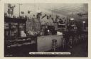
| Description: | Text on front reads: "The 'Friendly Buckhorn,' Rice Lake, Wisconsin." Text on reverse reads: "No vacation trip to Northern Wisconsin is complete without a ... |
| Date: | 1925 |
|---|---|
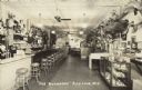
| Description: | Text on front reads: "'The Buckhorn,' Rice Lake, Wis." The Buckhorn Tavern had an amazing display of taxidermy and curios, including some hoaxes: a shovel-... |
If you didn't find the material you searched for, our Library Reference Staff can help.
Call our reference desk at 608-264-6535 or email us at: