 Filter: Categories of Wisconsin Historical Images
Filter: Subject of Apostle Islands
Filter: Subject of water
Filter: Categories of Wisconsin Historical Images
Filter: Subject of Apostle Islands
Filter: Subject of water

| Date: | 1906 |
|---|---|
| Description: | This map shows bays, creeks, railroads and rivers. Relief is shown by contours and spot heights. Depths are shown by contours, tints, and soundings. Includ... |

| Date: | 1947 |
|---|---|
| Description: | This map shows the territories of Chippewa, Sioux, Winnebago, and Monomone tribes. It also shows navigation notes for rivers and lakes, Indian villages, hi... |

| Date: | |
|---|---|
| Description: | Two women and a man are walking down the dock near a boat named "Chippewa" on Rocky Island.c South Twin Island is across the water in the background. |

| Date: | 08 1971 |
|---|---|
| Description: | Aerial view of Madeline Island, and a few of the Apostle Islands in the distance. |

| Date: | 08 1971 |
|---|---|
| Description: | View across water towards two seagulls resting on a rock outcropping of Stockton Island. Trees are growing on the top of the formation. |
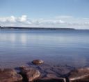
| Date: | |
|---|---|
| Description: | View from rocky shoreline of towards one of the Apostle Islands across the water. |
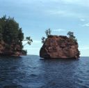
| Date: | 08 1971 |
|---|---|
| Description: | View across water towards two rock formations on the coast of Stockton Islands. |
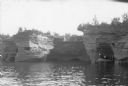
| Date: | 1920 |
|---|---|
| Description: | View across water towards three men and a woman posing while standing in a wooden boat in a sea cave in the Apostle Islands. Rock formations and other sea ... |
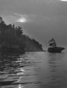
| Date: | 1940 |
|---|---|
| Description: | The moon, partially obstructed by clouds, is reflected in the waters off one of the Apostle Islands. There is a small islet on the right, with several tree... |
If you didn't find the material you searched for, our Library Reference Staff can help.
Call our reference desk at 608-264-6535 or email us at: