 Filter: Categories of Wisconsin Historical Images
Filter: Subject of Apostle Islands
Filter: Subject of islands
Filter: Subject of transportation
Filter: Categories of Wisconsin Historical Images
Filter: Subject of Apostle Islands
Filter: Subject of islands
Filter: Subject of transportation
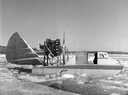
| Date: | 1955 |
|---|---|
| Description: | This was the first boat & sled-type wind sled built on Madeline Island. Built by Elmer Nelson for Howard Russell between 1950-1951. Had a 9-cylinder R-680-... |

| Date: | 1886 |
|---|---|
| Description: | Bird's-eye view of Ashland, on the shores of Lake Superior, with insets of The Apostle Islands Chequamagon Bay & Ashland, and Distances from Ashland. |

| Date: | 1886 |
|---|---|
| Description: | Bird's-eye view of Bayfield, county seat of Bayfield County. On the lower left side is an inset for Bayfield and the Apostle Islands. |

| Date: | 1886 |
|---|---|
| Description: | Bird's-eye map of Washburn on Lake Superior. There is an inset of Washburn, Chequamagon and the Apostle Islands. |

| Date: | 02 26 1887 |
|---|---|
| Description: | Bird's-eye map of Ashland, and the Apostle Islands in Lake Superior. Caption reads: "Ashland and the Apostle Islands." |
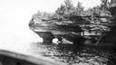
| Date: | |
|---|---|
| Description: | Devils Island on Lake Superior, outermost of the Apostle Islands group. There appears to be the edge of a boat in the foreground. |

| Date: | 1905 |
|---|---|
| Description: | Camp Stella looking south toward the Bayfield County shoreline from an Apostle Island. |
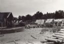
| Date: | 1915 |
|---|---|
| Description: | Building, boats, and fish net drying reels on South Twin Island in the Apostle Islands archipelago. |
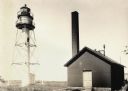
| Date: | |
|---|---|
| Description: | La Pointe Light on Long Island (Apostle Islands), Chequamegon Bay, Lake Superior. |
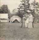
| Date: | 1915 |
|---|---|
| Description: | Women standing at General Fifield's Camp Stella at Sand Island, Apostle Island, Lake Superior. |
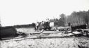
| Date: | 08 29 1922 |
|---|---|
| Description: | Men and boys are on a hand-pump rail cart on a Michigan Island beach, Lake Superior. A young girl is walking on the right. |
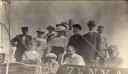
| Date: | 1917 |
|---|---|
| Description: | Group of people on boat "Zenya" at Hermit Island boat landing. L. to r. in back: Captain Angus; Mrs. Stickae; Florence Baker; Mrs. Baker; Elizabeth Abern... |

| Date: | 1878 |
|---|---|
| Description: | A color map detailing Ashland and Bayfield counties, including Lake Superior and the Apostle Islands. |

| Date: | 1884 |
|---|---|
| Description: | A detailed, hand-colored map of Wisconsin and the western portion of Michigan’s Upper Peninsula, which also includes an inset of Isle Royale in Lake Superi... |

| Date: | 1907 |
|---|---|
| Description: | A map of the eastern portion of the Apostle Islands group, and a detailed map of Gull Island showing the relief on the island, are included here, along wit... |

| Date: | 1916 |
|---|---|
| Description: | This map is mounted on cloth and shows lots and roads. An inset map is included that shows towns, lakes, rivers, and railroads within portions of the Dakot... |
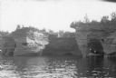
| Date: | 1920 |
|---|---|
| Description: | View across water towards three men and a woman posing while standing in a wooden boat in a sea cave in the Apostle Islands. Rock formations and other sea ... |
If you didn't find the material you searched for, our Library Reference Staff can help.
Call our reference desk at 608-264-6535 or email us at: