 Filter: Categories of Wisconsin Historical Images
Filter: Subject of Agriculture
Filter: Subject of ships
Filter: Subject of industries
Filter: Categories of Wisconsin Historical Images
Filter: Subject of Agriculture
Filter: Subject of ships
Filter: Subject of industries

| Date: | 1874 |
|---|---|
| Description: | Bird's-eye map of Chippewa Falls. |
| Date: | |
|---|---|
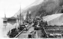
| Description: | View of Moore's Wharf with shipments standing on it, including pens with livestock. |

| Date: | |
|---|---|
| Description: | Memohead of the Plankinton Packing Company, a pork and beef packer and provision dealer in Milwaukee, Wisconsin. Includes an elevated view of the company b... |
| Date: | 1871 |
|---|---|
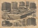
| Description: | Collage depicting multiple McCormick buildings reconstructed or built after the Chicago Fire. The caption at bottom reads, "Rebuilt Chicago. — Buildings Er... |

| Date: | 1755 |
|---|---|
| Description: | Map of Virginia and parts of Maryland, North Carolina, and New Jersey. It shows borders, boundary lines, some Native American land, counties, cities, towns... |

| Date: | 1950 |
|---|---|
| Description: | View towards a man driving a TD-24. In the background are cranes, and a ship at the shoreline. Subject: "TD-24 — Material Handling." Where Taken: "MW." Inf... |
If you didn't find the material you searched for, our Library Reference Staff can help.
Call our reference desk at 608-264-6535 or email us at: