 Filter: Categories of Wisconsin Historical Images
Filter: Subject of Agriculture
Filter: Subject of outdoor photography
Filter: Subject of lakes
Filter: Categories of Wisconsin Historical Images
Filter: Subject of Agriculture
Filter: Subject of outdoor photography
Filter: Subject of lakes
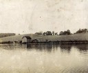
| Date: | 1916 |
|---|---|
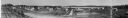
| Description: | Panoramic view of the Wingra area from the railroad tracks north of Gregory Street. Looking towards Lake Wingra, across Monroe Street. |
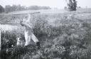
| Date: | 05 10 1917 |
|---|---|
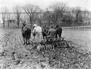
| Description: | Farmer pulling a Deering double disc harrow with four horses in a field. A lake, trees and houses are in the distance. |
| Date: | 1926 |
|---|---|
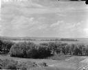
| Description: | Elevated view of Picnic Point on Lake Mendota from the University of Wisconsin-Madison Soils building. |
| Date: | 1906 |
|---|---|
| Description: | View of University Heights, showing a number of university buildings on the agricultural campus, including a windmill. Lake Mendota is in the far backgroun... |
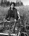
| Date: | 1960 |
|---|---|
| Description: | An Ojibwa woman, Francis Mike, harvesting wild rice in a boat on Totogatic Lake. |
| Date: | 1888 |
|---|---|
| Description: | View of shoreline along Picnic Point on the University of Wisconsin-Madison campus showing the home of Professor William Daniels, head of the Chemistry Dep... |
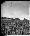
| Date: | 1875 |
|---|---|
| Description: | View from Southeast shore of Lake Monona across a cornfield, perhaps on the farm of Thomas Williamson. |
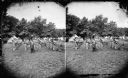
| Date: | 1876 |
|---|---|
| Description: | Quite possibly this is the "View of the Grand Music Band" listed in the "Centennial Views of the City of Madison, July 4th, 1876. Views of Chicago Light Gu... |

| Date: | 1874 |
|---|---|
| Description: | Distant view of the town from a hill with houses, garden plots, businesses and churches. |

| Date: | 03 24 1913 |
|---|---|
| Description: | Picnic Point from the University Farm fields, now known as Observatory Hill. |
| Date: | |
|---|---|
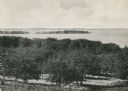
| Description: | Picnic Point from University drive, currently known as Observatory Hill. There are orchards in the foreground. |

| Date: | 1930 |
|---|---|
| Description: | Aerial view of near west side, including West High School, the Forest Products Laboratory, Lake Mendota, and Picnic Point. |

| Date: | 1909 |
|---|---|
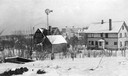
| Description: | View from Sunset Point in Owen Park, which is now a part of Hoyt Park. Lake Mendota is in the distance. |

| Date: | 1909 |
|---|---|
| Description: | View from the University of Wisconsin service building smokestack of south Madison, including Mills Street, Mound Street, and the Greenbush. Lake Monona is... |
| Date: | 1913 |
|---|---|
| Description: | Photographic mock-up for an Alfred Stanley Johnson photomontage postcard entitled "Kickers." A boy wearing waders and holding a rifle stands with his arms ... |

| Date: | 1910 |
|---|---|
| Description: | View down road towards a man and a dog standing next to a horse-drawn McCormick grain binder near a lake. |

| Date: | 1900 |
|---|---|
| Description: | Elevated view looking towards Monona Bay, possibly from atop the University of Wisconsin Power Plant smokestack. |
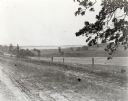
| Date: | |
|---|---|
| Description: | View from the western countryside towards Lake Wingra, looking east. In the foreground is a dirt road and fence. |

| Date: | |
|---|---|
| Description: | Near Lake Minocqua. View of rear of car driving on narrow dirt road lined with trees along lake which is on the right. A barn and silo are on the shoreline... |
If you didn't find the material you searched for, our Library Reference Staff can help.
Call our reference desk at 608-264-6535 or email us at:
