 Filter: Categories of Wisconsin Historical Images
Filter: Subject of Agriculture
Filter: Subject of land use, rural
Filter: Subject of forests and forestry
Filter: Categories of Wisconsin Historical Images
Filter: Subject of Agriculture
Filter: Subject of land use, rural
Filter: Subject of forests and forestry
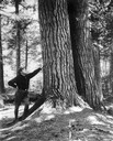
| Date: | 01 01 1934 |
|---|---|
| Description: | Man in uniform leaning up against the base of a large tree. |
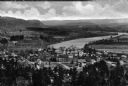
| Date: | |
|---|---|
| Description: | Elevated view of country town showing large. There are wooden buildings alongside the Delaware River which curves through fields and patches of woods in th... |

| Date: | 1935 |
|---|---|
| Description: | This map shows in different colors virgin timberland, second growth timber, pasture belt, crop-pasture belt, intensive crop-pasture belt, intensive pasture... |
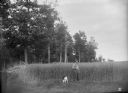
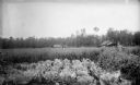
| Date: | 07 19 1895 |
|---|---|
| Description: | Man and dog standing in a field of spring wheat on the farm of Ferdinand Ledke. Another man is standing in the background, facing the forest. |
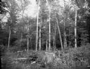
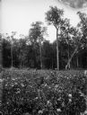
| Date: | 08 02 1895 |
|---|---|
| Description: | A hardwood forest ten miles southwest of Florence, containing hard maple, birch, elm, oak, hemlock, and other types of timber. Two men are leaning against ... |
| Date: | 08 02 1895 |
|---|---|
| Description: | Two men stand waist-high in the cabbage, pea, and oat fields of the C.C. Washburn homestead, twelve miles southwest of Florence. Wooden houses or outbuildi... |

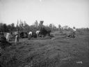
| Date: | 07 30 1895 |
|---|---|
| Description: | Two men stand in the five-foot tall pea field of Joseph Seipold three miles northeast of Antigo. Another man stands atop a horse-drawn wagon loaded with ha... |
| Date: | 08 01 1895 |
|---|---|
| Description: | A field of potato plants, with a forest in the background. A man is leaning against a basswood or linden tree that stands approximately eighty-five feet ta... |
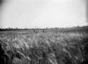
| Date: | 07 09 1895 |
|---|---|
| Description: | A twenty-acre field of barley on the farm of Chas Parey, with two men standing waist-high in the barley. A hardwood forest lines the edge of the field in t... |
| Date: | 09 03 1895 |
|---|---|
| Description: | The Fred Judas family poses with their second crop of red clover, three miles south of Medford. With their rakes and mower, they are converting the red clo... |

| Date: | 08 1960 |
|---|---|
| Description: | This map shows a detailed account of southwestern Wisconsin. Individual settlers, the type of trees that grow in given areas, the quality of the soil (labe... |

| Date: | 1970 |
|---|---|
| Description: | This map shows colored-coded land use with a legend in the bottom margin. Land classifications include: Year-round Residential (yellow), Seasonal Residenti... |

| Date: | 1776 |
|---|---|
| Description: | Fairly detailed map of New York City and parts of Long Island. It shows streets, roads, wharves, ferries, ship yards, Fort George and the battery, public b... |

| Date: | 04 28 2015 |
|---|---|
| Description: | View down a gravel path leading into a forest. The trees are bare of leaves, but the grass is green. A wood marker is at the intersection of a dirt path on... |
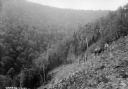
| Date: | 08 08 1927 |
|---|---|
| Description: | View down steep hillside, a section of which appears to be recently cleared. Two men are standing near a horse, halfway down the hill in the cleared area. ... |
If you didn't find the material you searched for, our Library Reference Staff can help.
Call our reference desk at 608-264-6535 or email us at: