Filter: Categories of Wisconsin Historical Images
Filter: Subject of Agriculture
Filter: Subject of aerial photographs
Filter: Subject of landscape
Filter: Categories of Wisconsin Historical Images
Filter: Subject of Agriculture
Filter: Subject of aerial photographs
Filter: Subject of landscape

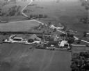
| Date: | 1958 |
|---|---|
| Description: | Aerial view of contour strip farming with the Obert Olstad farm in foreground. The Carl Backum farm is in the background. |
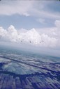
| Date: | 06 1962 |
|---|---|
| Description: | Distant view of U.S helicopters over the Delta Region of South Vietnam taken by Dickey Chapelle, a freelance photographer from Milwaukee. |

| Date: | |
|---|---|
| Description: | Aerial view of a train crossing the East River in a rural community south of Green Bay. Some buildings are visible to the right and the background of the i... |

| Date: | 1957 |
|---|---|
| Description: | Aerial view of Yellowstone Lake and surrounding countryside. |

| Date: | 1979 |
|---|---|
| Description: | Aerial view of Interstate I-90/94 at Camp Douglas, looking northwest. |
| Date: | 09 10 1947 |
|---|---|
| Description: | Aerial view of the River View Cannery. |

| Date: | 10 10 1947 |
|---|---|
| Description: | Aerial view of Dundas cannery. |
| Date: | 10 12 1947 |
|---|---|
| Description: | Aerial view of Cuba City Cannery. |

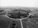
| Date: | 04 30 1949 |
|---|---|
| Description: | Aerial photograph of Blanchardville. |

| Date: | 04 30 1949 |
|---|---|
| Description: | Aerial photograph of contour farming in Wisconsin. |
| Date: | |
|---|---|
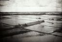
| Description: | Elevated view of helicopters flying over rice fields in Vietnam. |

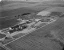
| Date: | 1950 |
|---|---|
| Description: | Aerial view of a farm and surrounding fields farmed with the contour method. Shocks of grain dot several of the fields. |
| Date: | 1936 |
|---|---|
| Description: | Aerial view of Cable, in northern Wisconsin. Text at foot reads: "Airplane View of Cable, Wis. 244." |
| Date: | 09 1996 |
|---|---|
| Description: | "As you look north, North Pole Road intersects DD. At the right is Theresa Station." |
| Date: | 09 1996 |
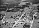
|---|---|
| Description: | "As we approach Firemen's Park, we are at the end of our ride." |

| Date: | 1950 |
|---|---|
| Description: | Aerial view of town, showing all of Lake Metonga in the background. Caption reads: "Greetings from Crandon, Wisconsin." |
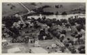
| Date: | |
|---|---|
| Description: | Photographic postcard aerial view of Ettrick. A river is running through town. Dwellings and commercial buildings are surrounded by fields. |

| Date: | |
|---|---|
| Description: | Aerial Ektachrome postcard of the Holy Hill shrine and surrounding landscape. Text on reverse reads: "Holy Hill Shrine of Mary — Help of Christians U.S... |
| Date: | 1979 |
|---|---|
| Description: | Text on reverse reads: "Madison, Wisconsin photographed on infrared film at an altitude of 22 miles from a NASA research aircraft. Red = vegetation Blue ... |
If you didn't find the material you searched for, our Library Reference Staff can help.
Call our reference desk at 608-264-6535 or email us at: