Filter: Categories of Wisconsin Historical Images
Filter: Subject of Agriculture
Filter: Subject of aerial photographs
Filter: Creator Name of Vinje, Arthur M., 1888-1972
Filter: Categories of Wisconsin Historical Images
Filter: Subject of Agriculture
Filter: Subject of aerial photographs
Filter: Creator Name of Vinje, Arthur M., 1888-1972

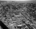
| Date: | 10 1928 |
|---|---|
| Description: | Aerial view of Sun Prairie, including the central business district, residences, and the surrounding countryside stretching to the horizon. |
| Date: | 1930 |
|---|---|
| Description: | Aerial view of the Lake Delview Hotel, the golf course, and the surrounding countryside. |

| Date: | 1930 |
|---|---|
| Description: | Aerial view of near west side, including West High School, the Forest Products Laboratory, Lake Mendota, and Picnic Point. |
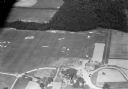
| Date: | 09 10 1947 |
|---|---|
| Description: | Aerial view of the River View Cannery. |

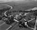
| Date: | 10 10 1947 |
|---|---|
| Description: | Aerial view of Dundas cannery. |
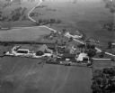
| Date: | 10 12 1947 |
|---|---|
| Description: | Aerial view of Cuba City Cannery. |
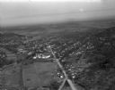
| Date: | 01 30 1949 |
|---|---|
| Description: | Aerial view of town, with a large building on a town square in the center. The edges of town are bordered by fields and farms. |

| Date: | 02 09 1949 |
|---|---|
| Description: | Three aerial views of the John Fluckiger farm and farm buildings amid snow-covered fields near Verona, operated by son Ivan Fluckiger. |

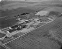
| Date: | 02 09 1949 |
|---|---|
| Description: | One of four aerial views of the Edwin Blaney farm and farm buildings surrounded by snow-covered fields. Four miles south of Madison and a mile west of U.S.... |
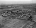
| Date: | 03 28 1949 |
|---|---|
| Description: | Aerial photographs of Richland Center, Wisconsin. |
| Date: | 04 27 1949 |
|---|---|
| Description: | Aerial view of the Veterans Hospital at Tomah. |

| Date: | 04 30 1949 |
|---|---|
| Description: | Aerial photograph of Blanchardville. |

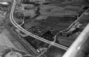
| Date: | 04 30 1949 |
|---|---|
| Description: | Aerial photograph of contour farming in Wisconsin. |
| Date: | 1958 |
|---|---|
| Description: | Aerial view of Kapec Orchards on Verona Road between McKee and Nesbitt Roads. |
If you didn't find the material you searched for, our Library Reference Staff can help.
Call our reference desk at 608-264-6535 or email us at: