 Filter: Categories of Wisconsin Historical Images
Filter: Subject of African Americans
Filter: Subject of loading docks
Filter: Categories of Wisconsin Historical Images
Filter: Subject of African Americans
Filter: Subject of loading docks
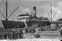
| Date: | 1910 |
|---|---|
| Description: | View of a dock, as naval stores are being loaded on a ship. Workers are on board the ship and on the dock, surrounded by cargo. Caption reads: "Loading Nav... |

| Date: | 1755 |
|---|---|
| Description: | Map of Virginia and parts of Maryland, North Carolina, and New Jersey. It shows borders, boundary lines, some Native American land, counties, cities, towns... |
If you didn't find the material you searched for, our Library Reference Staff can help.
Call our reference desk at 608-264-6535 or email us at: