Filter: Categories of Wisconsin Historical Images
Filter: Subject of Aerial photographs
Filter: Categories of Wisconsin Historical Images
Filter: Subject of Aerial photographs

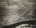
| Date: | 1945 |
|---|---|
| Description: | An aerial view of the Portage Canal, Fox and Wisconsin Rivers. |
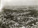
| Date: | 1945 |
|---|---|
| Description: | An elevated view of Portage and it's vicinity. |

| Date: | 1930 |
|---|---|
| Description: | Aerial view looking east at Mt. Trempealeau from Brady's Bluff in Perrot State Park. The Mississippi River is visible along the bluffs at upper left, and t... |

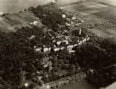
| Date: | 1965 |
|---|---|
| Description: | Elevated view of roads, railroad tracks, building, farm fields, and a body of water. |

| Date: | 1915 |
|---|---|
| Description: | Advertisement reads: "Castle-Pierce Printing Company" and "Feb. 1915". Text on right reads: "The Heart of Oshkosh. This birds-eye view represents about one... |
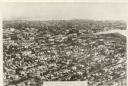
| Date: | 1931 |
|---|---|
| Description: | Aerial view of the city. Caption reads: "The finest aerial view of Oshkosh, Wis. ever made. Practically the entire town is included in this comprehensive p... |
| Date: | 1935 |
|---|---|
| Description: | Aerial view of the Northern Wisconsin Hospital for the Insane. |
| Date: | |
|---|---|
| Description: | Aerial view of Dell View Hotel and Lake Delton airport. |

| Date: | 1950 |
|---|---|
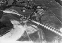
| Description: | Aerial view of the Highway 21 bridge and Petenwell Dam on the Wisconsin River. |
| Date: | 1958 |
|---|---|
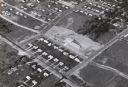
| Description: | Aerial view of Orchard Ridge School, at 5602 Russett Road. |

| Date: | 08 1986 |
|---|---|
| Description: | Aerial View of Wisconsin State Capitol. |

| Date: | 05 08 1946 |
|---|---|
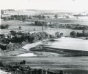
| Description: | Aerial view of rural lake shoreline showing farm and settlements. |

| Date: | |
|---|---|
| Description: | Aerial view of Wisconsin State Capitol. |
| Date: | |
|---|---|
| Description: | Aerial view of a portion of Ice Age Trail taken from a hot air balloon. |

| Date: | 1947 |
|---|---|
| Description: | Aerial view of Monroe. A large building with a clock tower, commercial buildings, parking lots and automobiles can be seen. |

| Date: | 1939 |
|---|---|
| Description: | Aerial view of commercial section of Monroe, WI. Green County Courthouse is pictured in the middle of the town square. |
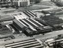
| Date: | 1924 |
|---|---|
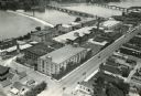
| Description: | Aerial view of the International Harvester Rock Falls Works (factory). |
| Date: | |
|---|---|
| Description: | Aerial view of the International Harvester Company building and surrounding industrial area in Durban, Natal, South Africa. The building is located in the ... |

| Date: | 1939 |
|---|---|
| Description: | Aerial view of International Harvester's Geelong Works in Geelong, Victoria, Australia. |
If you didn't find the material you searched for, our Library Reference Staff can help.
Call our reference desk at 608-264-6535 or email us at: