Filter: Categories of Wisconsin Historical Images
Filter: Subject of Aerial photographs
Filter: Categories of Wisconsin Historical Images
Filter: Subject of Aerial photographs
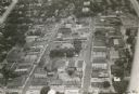
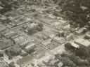
| Date: | 1957 |
|---|---|
| Description: | Aerial view of town with multiple buildings and a water tower visible in the background. |
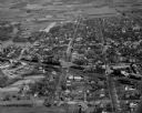
| Date: | 1939 |
|---|---|
| Description: | Aerial view of church and surrounding buildings. |
| Date: | 1953 |
|---|---|
| Description: | Aerial view of International Harvester's Phoenix Proving Ground. Opened in 1947, the proving ground was used by International Harvester through the 1970's ... |
| Date: | 1954 |
|---|---|
| Description: | Aerial view of the Phoenix Proving Ground during the 1954 Industrial Power Roundup, a large event promoting International Harvester's construction equipmen... |
| Date: | 1966 |
|---|---|
| Description: | Aerial view of International Harvester's Phoenix Proving Ground. Opened in 1947, the proving ground was used by International Harvester through the 1970's ... |

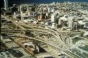
| Date: | 1998 |
|---|---|
| Description: | North-facing aerial view of the interchange between Interstates 39/90 and US Routes 12/18 in the southeast of Madison. Femrite Drive can be seen passing be... |
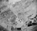
| Date: | 1951 |
|---|---|
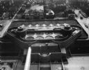
| Description: | Aerial view of the Johnson Wax Company building. |
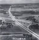
| Date: | 1960 |
|---|---|
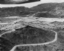
| Description: | Aerial view of the intersection of the interstate highway with USH 12 between Baraboo and Lake Delton with the initial grading largely completed. |

| Date: | 1960 |
|---|---|
| Description: | Aerial view of the construction of the interstate highway near Mirror Lake, showing only the early stages of the bridge construction. |

| Date: | 11 1951 |
|---|---|
| Description: | Aerial view of US Highway 14 southeast of La Crosse descending into Mormon Coulee. The original caption of the print, which is undated, describes the road ... |
| Date: | 1967 |
|---|---|
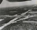
| Description: | Intersection of US Highway 41 and Wisconsin Highway 26 near Oshkosh. |
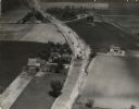
| Date: | 1935 |
|---|---|
| Description: | Aerial view of the paving operation of Joseph D. Bonners, Inc., on St. Martins Road at Hales Corners. |

| Date: | 1979 |
|---|---|
| Description: | Aerial view of Interstate I-90/94 at Camp Douglas, looking northwest. |
| Date: | 1979 |
|---|---|
| Description: | Interstate I-90 and State Highway 35 at La Crosse. |

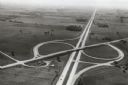
| Date: | 10 16 1962 |
|---|---|
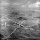
| Description: | The intersection of Interstate Highway I-90 and USH 12/18 east of Madison. This view looks toward the southeast |

| Date: | 1975 |
|---|---|
| Description: | Aerial view of Milwaukee County Stadium and the intersection of US 41 and I-94. County Stadium was built in 1953 and demolished in 2001. Although undated... |

| Date: | 1965 |
|---|---|
| Description: | Aerial view of early construction at the Marquette Interchange in Milwaukee, the junction of Interstate Highways I94 and I43. Construction began in 1964, ... |
| Date: | |
|---|---|
| Description: | Aerial view of the first Marquette Interchange, photographed some time after its completion in 1968. |
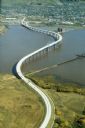
| Date: | 1985 |
|---|---|
| Description: | Aerial view of the Duluth-Superior Bridge, officially named in honor of Richard I. Bong, World War II's Ace of Aces, who hailed from nearby Poplar, Wiscons... |
If you didn't find the material you searched for, our Library Reference Staff can help.
Call our reference desk at 608-264-6535 or email us at: