Filter: Categories of Wisconsin Historical Images
Filter: Subject of Aerial photographs
Filter: Year of 1900-1999
Filter: Year of 1920-1929
Filter: Categories of Wisconsin Historical Images
Filter: Subject of Aerial photographs
Filter: Year of 1900-1999
Filter: Year of 1920-1929

| Date: | 06 27 1927 |
|---|---|
| Description: | Aerial view of the effigy mound on Henry Wehmhoff's Riverview Farm. State Trunk Highway 83 runs through the effigy. |

| Date: | 1928 |
|---|---|
| Description: | Aerial view of the Wisconsin State Capitol, looking northeast. The Park Hotel on the corner of W. Main Street and S. Carroll Street, is in the foreground. |
| Date: | 1925 |
|---|---|
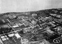
| Description: | Aerial photograph taken as part of a survey by the Wisconsin Power and Light Company to promote economic development by emphasizing available buildings and... |
| Date: | 1925 |
|---|---|
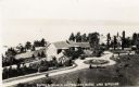
| Description: | Aerial view of Woods' Manor on shores of Madeline Island. The manor was built in 1900 for summer resident Colonel Frederick Woods from Nebraska. |

| Date: | 07 21 1921 |
|---|---|
| Description: | One of the most important moments in the history of American aviation - the sinking of the captured German battleship "Ostfriesland" by American bombers of... |
| Date: | 08 1929 |
|---|---|
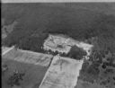
| Description: | Aerial view of the Dane County Tuberculosis Sanitorium under construction, at 1202 Northport Drive. J.P. Cullen, Contractor. |
| Date: | 1923 |
|---|---|
| Description: | Aerial view of the University of Wisconsin campus shows from west to east the Agricultural Hall, Observatory Hall and the Wisconsin Historical Society with... |

| Date: | 1926 |
|---|---|
| Description: | Originally titled 'Recent Aeroplane View of University Campus', the view of the Wisconsin Historical Society, the Red Gym, Science Hall and Bascom Hall wit... |

| Date: | 1923 |
|---|---|
| Description: | Aerial view of the Wisconsin Historical Society, Science Hall, and Bascom Hall on Bascom Hill on the University of Wisconsin-Madison campus. Lake Mendota i... |
| Date: | 1923 |
|---|---|
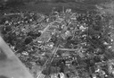
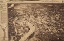
| Description: | Aerial view of town with river. The clipping from a newspaper has a description titled: "Seeing Wisconsin From an Airplane". |

| Date: | 1920 |
|---|---|
| Description: | Aerial view of the last covered bridge, which is no longer standing. |

| Date: | 1922 |
|---|---|
| Description: | Aerial view of the Wisconsin State Capitol and Lake Monona. |

| Date: | 1928 |
|---|---|
| Description: | Aerial view of Madison looking southeast over the isthmus, showing the Four Lakes Country. Visible at the bottom is the Lake Mendota shoreline. At center, ... |

| Date: | 1925 |
|---|---|
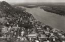
| Description: | Caption reads: "Bird's Eye View of Fountain City, Wis. M-1255". Aerial view of town with the river on the right. |

| Date: | 1925 |
|---|---|
| Description: | Bird's-eye view of Fountain City looking south, with high bluff on the left, and the Mississippi River on the right. Fountain City, about 4 blocks wide, ne... |

| Date: | 1924 |
|---|---|
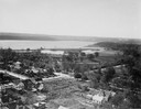
| Description: | Aerial view of Madison's Willow Beach towards the University of Wisconsin-Madison campus, downtown Madison, and Lake Monona. |
| Date: | 1924 |
|---|---|
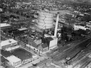
| Description: | Aerial view of a Madison Gas and Electric steam plant. |
| Date: | 1924 |
|---|---|
| Description: | Aerial view looking southwest over Madison's Vilas Park. |
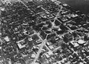
| Date: | 1928 |
|---|---|
| Description: | Aerial view of Capitol Square and vicinity, looking east-northeast. State Street is visible at the bottom center. |
If you didn't find the material you searched for, our Library Reference Staff can help.
Call our reference desk at 608-264-6535 or email us at: