Filter: Categories of Wisconsin Historical Images
Filter: Subject of Aerial photographs
Filter: Year of 1900-1999
Filter: Categories of Wisconsin Historical Images
Filter: Subject of Aerial photographs
Filter: Year of 1900-1999
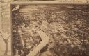
| Date: | 1923 |
|---|---|
| Description: | Aerial view of town with river. The clipping from a newspaper has a description titled: "Seeing Wisconsin From an Airplane". |

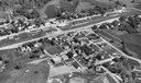
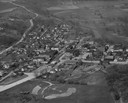
| Date: | 1965 |
|---|---|
| Description: | Aerial view of downtown Big Falls and the Little Wolf River. The Little Wolf River is at lower right. |
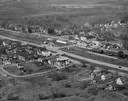
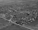
| Date: | 1957 |
|---|---|
| Description: | Aerial view including many buildings and a baseball diamond. |
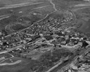
| Date: | 1957 |
|---|---|
| Description: | Air view of town, including multiple buildings and a cemetery. |

| Date: | 1920 |
|---|---|
| Description: | Aerial view of the last covered bridge, which is no longer standing. |

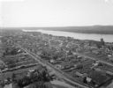
| Date: | 1910 |
|---|---|
| Description: | Aerial view of town, with a river and the horizon in the distance. |

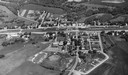
| Date: | 1905 |
|---|---|
| Description: | Aerial view of town, with several large buildings along railroad tracks in the foreground, and fields and trees in the distance. Pedestrians are walking al... |
| Date: | 1900 |
|---|---|
| Description: | Aerial view of town. The Mississippi River and far shoreline is in the background. The Furnace Branch creek runs through the town in the foreground. |

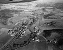
| Date: | 1955 |
|---|---|
| Description: | Aerial view of Cross Plains, with countryside surrounding and hills on the horizon. |
If you didn't find the material you searched for, our Library Reference Staff can help.
Call our reference desk at 608-264-6535 or email us at: