 Filter: Categories of Wisconsin Historical Images
Filter: Subject of Aerial photographs
Filter: Subject of water
Filter: Subject of transportation
Filter: Categories of Wisconsin Historical Images
Filter: Subject of Aerial photographs
Filter: Subject of water
Filter: Subject of transportation
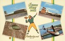
| Date: | 1957 |
|---|---|
| Description: | Composite image of "Packerland U.S.A." including prominent attractions: Lambeau Field, home of the Green Bay Packers, NFL Football team; the Brown County A... |

| Date: | 1965 |
|---|---|
| Description: | Aerial view of downtown Big Falls and the Little Wolf River. The Little Wolf River is at lower right. |

| Date: | 1920 |
|---|---|
| Description: | Aerial view of the last covered bridge, which is no longer standing. |
| Date: | 1910 |
|---|---|
| Description: | Aerial view of town, with a river and the horizon in the distance. |

| Date: | 1950 |
|---|---|
| Description: | Aerial view of main street. There is a bridge with a stream flowing under it in the foreground. |

| Date: | 1930 |
|---|---|
| Description: | Aerial view of Carson Park, Half Moon Lake and part of the West Side in the foreground. The municipal bath house is on the lake shore in the foreground. A ... |

| Date: | 1930 |
|---|---|
| Description: | Aerial view of city, with Eau Claire River is in the foreground with Milwaukee railroad bridge at left. Gillette Rubber Co. plant is in center with Omaha r... |

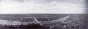
| Date: | 1931 |
|---|---|
| Description: | Aerial view looking north, with a small portion of the West Side (left), nearly all of the North Side and part of the business district of the East Side. A... |
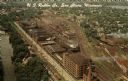
| Date: | |
|---|---|
| Description: | Aerial view of the plant, with railroad tracks along both sides of the property. A river is on the left. Several cars are parked at the plant. There is an... |

| Date: | 1957 |
|---|---|
| Description: | Aerial view of the north corner of Capitol Square looking toward Lake Mendota. The Belmont Hotel is featured prominently. |

| Date: | 1956 |
|---|---|
| Description: | Aerial view looking northeast from a point over the east end of Middleton, showing the west end of Lake Mendota (right mid-ground). Fox Bluff juts into the... |

| Date: | 1955 |
|---|---|
| Description: | An air view of Madison's downtown area with the Wisconsin State Capitol and new State Office Buildings. |

| Date: | 1956 |
|---|---|
| Description: | Aerial view looking east along Madison's Lake Mendota shoreline. The large building under construction at center is Carroll Hall, a University of Wisconsin... |

| Date: | 1925 |
|---|---|
| Description: | Bird's-eye view of Fountain City looking south, with high bluff on the left, and the Mississippi River on the right. Fountain City, about 4 blocks wide, ne... |

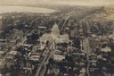
| Date: | 1919 |
|---|---|
| Description: | Aerial view from King Street looking southwest to the University of Wisconsin campus. |

| Date: | 1930 |
|---|---|
| Description: | Aerial view of isthmus looking east toward Lake Mendota and the Wisconsin State Capitol, with Lake Monona and the horizon in the background. |
| Date: | 1919 |
|---|---|
| Description: | Aerial view of the Capitol Square and surrounding area. Lake Monona and Lake Wingra are in the background. |
If you didn't find the material you searched for, our Library Reference Staff can help.
Call our reference desk at 608-264-6535 or email us at:


