 Filter: Categories of Wisconsin Historical Images
Filter: Subject of Aerial photographs
Filter: Subject of water
Filter: County of Milwaukee
Filter: Categories of Wisconsin Historical Images
Filter: Subject of Aerial photographs
Filter: Subject of water
Filter: County of Milwaukee

| Date: | 1964 |
|---|---|
| Description: | Aerial view of the Milwaukee County Zoo grounds nearing its completion. |
| Date: | |
|---|---|
| Description: | Aerial view of buildings with Lake Michigan in the distance. |

| Date: | 11 16 2001 |
|---|---|
| Description: | Aerial view of General Mitchell International in Milwaukee, looking southeast to the Lake Michigan shoreline. |

| Date: | 04 01 1975 |
|---|---|
| Description: | The bridge over the Milwaukee Harbor named in honor of former Mayor Daniel Hoan. The bridge was constructed between 1970 and 1972, but during the period de... |

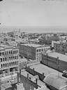
| Date: | |
|---|---|
| Description: | Elevated view looking northeast from the roof of the Wells Building at E. Wisconsin Avenue and N. Milwaukee Street. St. John's Cathedral is in the center o... |

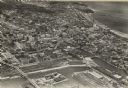
| Date: | 1951 |
|---|---|
| Description: | Aerial view of Jones Island and garbage disposal plant. |

| Date: | 1950 |
|---|---|
| Description: | Harbor area of Jones Island and garbage disposal plant, Stratton Grain Co., and more. |
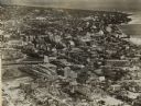
| Date: | |
|---|---|
| Description: | Aerial view looking north of downtown, with the Milwaukee River and Lake Michigan. |
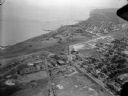
| Date: | 1938 |
|---|---|
| Description: | Aerial view of rivers, with Lake Michigan in upper right, train yards, and highway in lower left. |

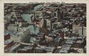
| Date: | 1922 |
|---|---|
| Description: | Aerial view of downtown with City Hall and Milwaukee River. |

| Date: | 1947 |
|---|---|
| Description: | City Hall near the Milwaukee River. |
| Date: | 1925 |
|---|---|
| Description: | Downtown aerial view with the Milwaukee River and City Hall. Caption reads: "Downtown Aerial View, Milwaukee, Wis." |

| Date: | 1940 |
|---|---|
| Description: | Aerial view of city, river and harbor. Two smokestacks are on either side of the river mouth. |

| Date: | 1953 |
|---|---|
| Description: | Aerial view looking north from the foot of Milwaukee's main thoroughfare, Wisconsin Avenue. Lincoln Memorial Drive winds its way along the lagoon in Juneau... |
| Date: | |
|---|---|
| Description: | Aerial view of lake, in the upper left. A town with dwellings and other buildings are along the shoreline. Part of the airplane is on the right. |
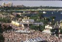
| Date: | 1982 |
|---|---|
| Description: | Bird's-eye view of a large crowd of music fans gathered at Summerfest, looking northeast toward the current site of Discovery World. Sailboats are on Lake ... |

| Date: | 06 14 1961 |
|---|---|
| Description: | Aerial view of North and South Harbor Tracts, looking north from South Pier No. 2. There are skyscrapers in the background. there are multiple items of mac... |
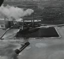
| Date: | 05 12 1959 |
|---|---|
| Description: | Aerial view of a large ship with a considerable amount of dark smoke coming from the rear. The ship appears to be heading toward a large field of coal buil... |

| Date: | 1960 |
|---|---|
| Description: | Construction Equipment Division. |
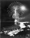
| Date: | 07 1973 |
|---|---|
| Description: | Aerial view of fireworks over Lake Michigan. Boats are moored in the harbor for a good view. |
If you didn't find the material you searched for, our Library Reference Staff can help.
Call our reference desk at 608-264-6535 or email us at: