 Filter: Categories of Wisconsin Historical Images
Filter: Subject of Aerial photographs
Filter: Subject of water
Filter: Type of Postcard
Filter: Subject of cities and towns
Filter: Categories of Wisconsin Historical Images
Filter: Subject of Aerial photographs
Filter: Subject of water
Filter: Type of Postcard
Filter: Subject of cities and towns

| Date: | 1957 |
|---|---|
| Description: | Composite image of "Packerland U.S.A." including prominent attractions: Lambeau Field, home of the Green Bay Packers, NFL Football team; the Brown County A... |
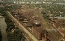
| Date: | |
|---|---|
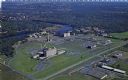
| Description: | Aerial view of the plant, with railroad tracks along both sides of the property. A river is on the left. Several cars are parked at the plant. There is an... |

| Date: | 1960 |
|---|---|
| Description: | Aerial view with docks in the foreground. Caption reads: "Superior, Wisconsin." |
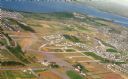
| Date: | 09 1958 |
|---|---|
| Description: | An aerial view of University Hill Farms on Madison's west side, a complete 604 acre community developed by the Regents of the University of Wisconsin. Real... |
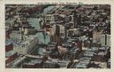
| Date: | 1925 |
|---|---|
| Description: | Downtown aerial view with the Milwaukee River and City Hall. Caption reads: "Downtown Aerial View, Milwaukee, Wis." |
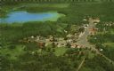
| Date: | 1959 |
|---|---|
| Description: | Color postcard of an aerial view of town. There is a lake in the background in the upper left. |

| Date: | 04 12 1907 |
|---|---|
| Description: | Photographic postcard of an aerial view of town looking North. The Mississippi River is on the left. |

| Date: | |
|---|---|
| Description: | Color postcard of an aerial view of Cerami's Island View Hotel Motel Resort on the shore of Brown's Lake. |
| Date: | |
|---|---|
| Description: | Photographic postcard of an aerial view of Lake Owen near Cable. Most of the lake is located within the Chequamegon National Forest. Caption reads: "Air Vi... |
| Date: | 07 29 1909 |
|---|---|
| Description: | Aerial view of the downtown area, including a bridge spanning the Trempealeau River. Caption reads: "View of Arcadia, Wisconsin." |
| Date: | 05 22 1906 |
|---|---|
| Description: | Aerial view of the city and rolling hills in the background. A bridge crossing the Trempealeau River is also visible. |

| Date: | 1972 |
|---|---|
| Description: | Aerial view of commercial buildings and dwellings along the shore of Lake Michigan. Caption reads: "Baileys Harbor, Wisc." |

| Date: | 1950 |
|---|---|
| Description: | Aerial view of town, showing all of Lake Metonga in the background. Caption reads: "Greetings from Crandon, Wisconsin." |

| Date: | 1950 |
|---|---|
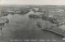
| Description: | Aerial view of the Island City surrounded by the waters of Beaver Dam Lake, and by a vacation and recreation area that includes some fifty lakes within a r... |

| Date: | 1910 |
|---|---|
| Description: | Aerial view along river toward Darlington. Caption reads: "Bird's-Eye View, Darlington, Wis." |
| Date: | 1950 |
|---|---|
| Description: | Aerial view of Sacred Heart Hospital. |

| Date: | |
|---|---|
| Description: | Aerial view of harbor, with shipyards in the foreground and Superior in the background. Caption reads: "Aerial View of Harbor, Superior, Wisconsin." |

| Date: | 1917 |
|---|---|
| Description: | View over the wing of a Lawson Military Tractor 2 (MT2) in flight. Below are houses and what may be a river or lake. Location is unknown, but is probably n... |
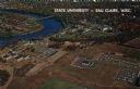
| Date: | 1967 |
|---|---|
| Description: | Aerial view of the State University adjacent to the Chippewa River. Caption reads: "State University - Eau Claire, Eau Claire, Wis." |
If you didn't find the material you searched for, our Library Reference Staff can help.
Call our reference desk at 608-264-6535 or email us at:
