Filter: Categories of Wisconsin Historical Images
Filter: Subject of Aerial photographs
Filter: Subject of transportation
Filter: Categories of Wisconsin Historical Images
Filter: Subject of Aerial photographs
Filter: Subject of transportation

| Date: | 1956 |
|---|---|
| Description: | Aerial view looking east along Madison's Lake Mendota shoreline. The large building under construction at center is Carroll Hall, a University of Wisconsin... |

| Date: | 1925 |
|---|---|
| Description: | Bird's-eye view of Fountain City looking south, with high bluff on the left, and the Mississippi River on the right. Fountain City, about 4 blocks wide, ne... |

| Date: | 1919 |
|---|---|
| Description: | Aerial view from King Street looking southwest to the University of Wisconsin campus. |

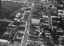
| Date: | 1955 |
|---|---|
| Description: | Aerial view of Atwood Avenue, looking west towards Winnebago Street and "Schenk's Corners." |

| Date: | 1930 |
|---|---|
| Description: | Aerial view of isthmus looking east toward Lake Mendota and the Wisconsin State Capitol, with Lake Monona and the horizon in the background. |
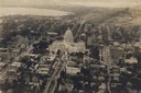
| Date: | 1919 |
|---|---|
| Description: | Aerial view of the Capitol Square and surrounding area. Lake Monona and Lake Wingra are in the background. |

| Date: | 1953 |
|---|---|
| Description: | Aerial view looking southeast over Madison's near east side. The Eagles Club at 1236 Jenifer Street / 1221 Williamson Street is under construction in the ... |
| Date: | 1920 |
|---|---|
| Description: | Aerial view of the commercial district on the east side of the Fox River. Left to right: Hurlbut Coal Company; suggested location for small terminal; Main... |
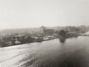
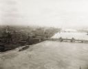
| Date: | 1924 |
|---|---|
| Description: | Aerial view of Green Bay's commercial district, bridges, and water. |
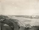
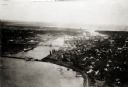
| Date: | 1920 |
|---|---|
| Description: | Aerial view with fishing piers, coal factories, a bridge, and railroad tracks. |
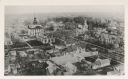
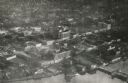
| Date: | 1890 |
|---|---|
| Description: | Aerial view of downtown Green Bay, with the old Court House. |
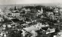
| Date: | 1890 |
|---|---|
| Description: | Aerial view of downtown Green Bay with old Court House and the surrounding buildings. |
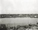
| Date: | 1903 |
|---|---|
| Description: | Aerial view of the Green Bay harbor area. |
| Date: | 1925 |
|---|---|
| Description: | Aerial view of Green Bay, including the Jorgensen-Blesch Company building and two bridges. |
| Date: | 1920 |
|---|---|
| Description: | Aerial view of with bridges, river, and shoreline. |

| Date: | 1950 |
|---|---|
| Description: | Aerial view of downtown and river. |

| Date: | |
|---|---|
| Description: | Aerial view of a train crossing the East River in a rural community south of Green Bay. Some buildings are visible to the right and the background of the i... |
If you didn't find the material you searched for, our Library Reference Staff can help.
Call our reference desk at 608-264-6535 or email us at: