Filter: Categories of Wisconsin Historical Images
Filter: Subject of Aerial photographs
Filter: Subject of transportation
Filter: Categories of Wisconsin Historical Images
Filter: Subject of Aerial photographs
Filter: Subject of transportation

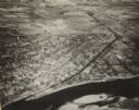
| Date: | 1945 |
|---|---|
| Description: | An aerial view of the Portage Canal, Fox and Wisconsin Rivers. |
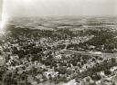
| Date: | 1945 |
|---|---|
| Description: | An elevated view of Portage and it's vicinity. |

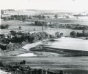
| Date: | 1965 |
|---|---|
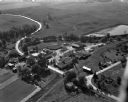
| Description: | Elevated view of roads, railroad tracks, building, farm fields, and a body of water. |

| Date: | 1915 |
|---|---|
| Description: | Advertisement reads: "Castle-Pierce Printing Company" and "Feb. 1915". Text on right reads: "The Heart of Oshkosh. This birds-eye view represents about one... |
| Date: | |
|---|---|
| Description: | Aerial view of Dell View Hotel and Lake Delton airport. |

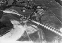
| Date: | 1950 |
|---|---|
| Description: | Aerial view of the Highway 21 bridge and Petenwell Dam on the Wisconsin River. |
| Date: | |
|---|---|
| Description: | Aerial view of a portion of Ice Age Trail taken from a hot air balloon. |

| Date: | 1947 |
|---|---|
| Description: | Aerial view of Monroe. A large building with a clock tower, commercial buildings, parking lots and automobiles can be seen. |
| Date: | 1924 |
|---|---|
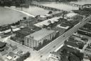
| Description: | Aerial view of the International Harvester Rock Falls Works (factory). |

| Date: | 1933 |
|---|---|
| Description: | Aerial view of International Harvester's Norrkoping Works in Norrkoping, Sweden. |
| Date: | 1954 |
|---|---|
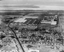
| Description: | An aerial view of the International Harvester Memphis Works in Memphis, Tennessee, with a view of the surrounding neighborhood and Loosahatchie River. The ... |
| Date: | 04 20 1944 |
|---|---|
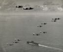
| Description: | Aerial view of three TBF's (all above the horizon) and eleven SBD's, which participated in Pacific Fleet's carrier-strike against Japan's bases in the Pala... |

| Date: | 05 05 1947 |
|---|---|
| Description: | Aerial view of the intersection of Pinckney, Main, and King Streets on the Madison Capitol Square. Kresge's, 27 East Main Street, can be seen at the upper ... |

| Date: | 05 05 1947 |
|---|---|
| Description: | Aerial view of Main, King, and Pinckney Streets intersection on Madison's Capitol Square. View is looking south down Pinckney Street. Kresge's, 27 East Mai... |

| Date: | 05 08 1947 |
|---|---|
| Description: | Aerial photograph of the Capitol Square area of Madison, looking to the southwest. |

| Date: | 09 1918 |
|---|---|
| Description: | Elevated view of the U.S. Government War Exposition grounds at Grant Park. |

| Date: | |
|---|---|
| Description: | Elevated view looking northeast from the roof of the Wells Building at E. Wisconsin Avenue and N. Milwaukee Street. St. John's Cathedral is in the center o... |
| Date: | 09 10 1947 |
|---|---|
| Description: | Aerial view of the River View Cannery. |

| Date: | 10 10 1947 |
|---|---|
| Description: | Aerial view of Dundas cannery. |
If you didn't find the material you searched for, our Library Reference Staff can help.
Call our reference desk at 608-264-6535 or email us at: