Filter: Categories of Wisconsin Historical Images
Filter: Subject of Aerial photographs
Filter: Subject of transportation
Filter: Categories of Wisconsin Historical Images
Filter: Subject of Aerial photographs
Filter: Subject of transportation
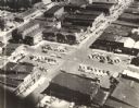
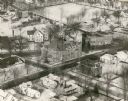
| Date: | 1955 |
|---|---|
| Description: | Aerial view of town, with commercial buildings, and cars in parking lots. |

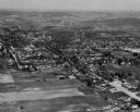
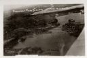
| Date: | 1965 |
|---|---|
| Description: | Aerial view that encompasses most of the town and part of the Wisconsin River. |

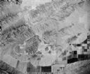
| Date: | 1945 |
|---|---|
| Description: | Aerial view of Taliesin, Frank Lloyd Wright's residence and architectural school complex, with the Wisconsin River visible at the top. Taliesin is located... |
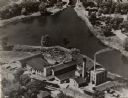
| Date: | 1949 |
|---|---|
| Description: | Aerial view of the George A. Whiting Paper Mill. |
| Date: | 1926 |
|---|---|
| Description: | Aerial view with Wisconsin River. Caption reads: "Schofield Home Coming June 16-17-18-1927". The wing of an airplane is in the right foreground. |
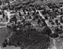
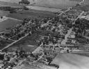
| Date: | 1925 |
|---|---|
| Description: | Aerial view of a neighborhood in Merrill. |
| Date: | 1965 |
|---|---|
| Description: | Aerial view, looking west, with potato warehouses in the foreground and a pallet factory and junkyard behind them at right. |
| Date: | 1957 |
|---|---|
| Description: | Aerial view of various buildings and roads. |
| Date: | 1953 |
|---|---|
| Description: | Aerial view of International Harvester's Phoenix Proving Ground. Opened in 1947, the proving ground was used by International Harvester through the 1970's ... |
| Date: | 1954 |
|---|---|
| Description: | Aerial view of the Phoenix Proving Ground during the 1954 Industrial Power Roundup, a large event promoting International Harvester's construction equipmen... |
| Date: | 1966 |
|---|---|
| Description: | Aerial view of International Harvester's Phoenix Proving Ground. Opened in 1947, the proving ground was used by International Harvester through the 1970's ... |

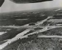
| Date: | 1998 |
|---|---|
| Description: | North-facing aerial view of the interchange between Interstates 39/90 and US Routes 12/18 in the southeast of Madison. Femrite Drive can be seen passing be... |
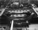
| Date: | 1951 |
|---|---|
| Description: | Aerial view of the Johnson Wax Company building. |
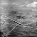
| Date: | 1960 |
|---|---|
| Description: | Aerial view of the intersection of the interstate highway with USH 12 between Baraboo and Lake Delton with the initial grading largely completed. |

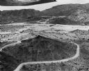
| Date: | 1960 |
|---|---|
| Description: | Aerial view of the construction of the interstate highway near Mirror Lake, showing only the early stages of the bridge construction. |

| Date: | 11 1951 |
|---|---|
| Description: | Aerial view of US Highway 14 southeast of La Crosse descending into Mormon Coulee. The original caption of the print, which is undated, describes the road ... |
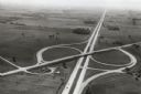
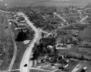
| Date: | 1967 |
|---|---|
| Description: | Intersection of US Highway 41 and Wisconsin Highway 26 near Oshkosh. |
If you didn't find the material you searched for, our Library Reference Staff can help.
Call our reference desk at 608-264-6535 or email us at: