 Filter: Categories of Wisconsin Historical Images
Filter: Subject of Aerial photographs
Filter: Subject of transportation
Filter: Creator Name of Vinje, Arthur M., 1888-1972
Filter: Categories of Wisconsin Historical Images
Filter: Subject of Aerial photographs
Filter: Subject of transportation
Filter: Creator Name of Vinje, Arthur M., 1888-1972

| Date: | 11 1928 |
|---|---|
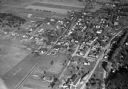
| Description: | Aerial view of Verona including businesses, houses, and the surrounding farm land. |
| Date: | 11 1928 |
|---|---|
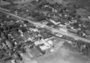
| Description: | Aerial view of Middleton including businesses, residences, the railroad tracks, and the surrounding countryside. |
| Date: | 1930 |
|---|---|
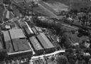
| Description: | Aerial view of the Highway Trailer plant at Edgerton. |
| Date: | 1930 |
|---|---|
| Description: | Aerial view of the town, including business, houses, and railroad tracks cutting through the town. |

| Date: | 10 1928 |
|---|---|
| Description: | Aerial view of Sun Prairie, including the central business district, residences, and the surrounding countryside stretching to the horizon. |

| Date: | 11 1928 |
|---|---|
| Description: | Aerial view of Stoughton, including the central business district, residential areas, the Yahara River, and the surrounding countryside. |

| Date: | 11 1928 |
|---|---|
| Description: | Aerial view residential areas of Windsor and the surrounding countryside. |

| Date: | 11 1928 |
|---|---|
| Description: | Aerial view of Black Earth residential area and the surrounding countryside. |

| Date: | 11 1928 |
|---|---|
| Description: | Aerial view of Cross Plains, including residences and the surrounding countryside. |
| Date: | 1935 |
|---|---|
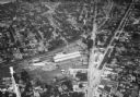
| Description: | Aerial view of the French Battery Company facility, East Washington Avenue, and Winnebago Street at the Union Corners intersection. |
| Date: | 10 06 1928 |
|---|---|
| Description: | Aerial view of the Janesville airport during air races including airplanes in the air, the landing field, and airport structures. |
| Date: | 1930 |
|---|---|
| Description: | Aerial view of airplane races at the Janesville airport, including airplanes on the landing field, airport structures, cars parked around the airport, and ... |
| Date: | 1930 |
|---|---|
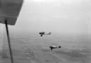
| Description: | Two airplanes refueling in flight over Morey Airport. The airport and farmland can be seen in the distance. |

| Date: | 1930 |
|---|---|
| Description: | Aerial view of Pennco Field (Royal Airport), and Lake Monona near the city limits. A crowd is gathered at the airport to watch an air show. |
| Date: | |
|---|---|
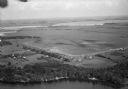
| Description: | Aerial view of Pennco Field (Royal Airport), the shoreline of Lake Monona, and the surrounding countryside near the city limits. |

| Date: | 1930 |
|---|---|
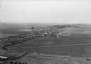
| Description: | Aerial view of the Pennco Field (Royal Airport), including the hanger and airplanes on the ground. Lake Monona, the Wisconsin State Capitol, and the Madiso... |

| Date: | |
|---|---|
| Description: | Aerial view of a crowd at the Pennco Field (Royal Airport), gathered for an aerial show. Biplanes possibly used for the show are on the airstrip. Automob... |

| Date: | 1930 |
|---|---|
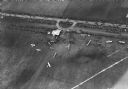
| Description: | Aerial view of the Pennco Field (Royal Airport) hanger surrounded by spectators gathered for an air show. Biplanes are parked on the grounds of the airpor... |

| Date: | 1930 |
|---|---|
| Description: | Aerial view of biplanes at the Pennco Field (Royal Airport), probably for an air show. Lake Monona is in the background. |

| Date: | 05 05 1947 |
|---|---|
| Description: | Aerial view of the intersection of Pinckney, Main, and King Streets on the Madison Capitol Square. Kresge's, 27 East Main Street, can be seen at the upper ... |
If you didn't find the material you searched for, our Library Reference Staff can help.
Call our reference desk at 608-264-6535 or email us at: