 Filter: Categories of Wisconsin Historical Images
Filter: Subject of Aerial photographs
Filter: Subject of suburbs
Filter: Categories of Wisconsin Historical Images
Filter: Subject of Aerial photographs
Filter: Subject of suburbs
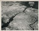
| Date: | 1948 |
|---|---|
| Description: | Aerial view of downtown area, with the Fox River and neighboring suburbs. |
| Date: | 04 21 1948 |
|---|---|
| Description: | Aerial photograph of the west side of Madison and the western edge of Lake Mendota. Taken over the west side of Madison looking northwest toward Middleton. |
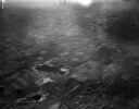
| Date: | 1939 |
|---|---|
| Description: | Elevated winter scene of Greendale (Milwaukee Co.), Wisconsin. Housing, roads and trees are visible in the distance. One person is walking through the snow... |
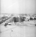
| Date: | 1939 |
|---|---|
| Description: | Elevated view of village with snow on the ground. A tennis court, flag pole, and pedestrians are visible in the foreground. Behind the tennis court are roa... |

| Date: | 12 23 1953 |
|---|---|
| Description: | Aerial view of Crawford Heights looking northwest across Nakoma Road. The photograph shows Nakoma Road, the West Beltline, Cherokee School, and Midvale Bou... |

| Date: | 12 23 1953 |
|---|---|
| Description: | Aerial view of Crawford Heights looking north along Midvale Boulevard. The photograph shows Nakoma Road, the West Beltline, Cherokee School, and Midvale Bo... |

| Date: | 12 23 1953 |
|---|---|
| Description: | Aerial view of Crawford Heights looking northeast along Nakoma Road, across the West Beltline. The photograph shows Midvale Boulevard and Lake Mendota appe... |

| Date: | 12 22 1953 |
|---|---|
| Description: | Aerial photograph of Crawford Heights looking west along the West Beltline. The photograph shows Nakoma Road, Midvale Boulevard, Cherokee School, and the A... |

| Date: | 12 23 1953 |
|---|---|
| Description: | Aerial view of Crawford Heights looking west along the West Beltline. The photograph shows Nakoma Road, Midvale Boulevard, Cherokee School, and the Arboret... |

| Date: | 12 23 1953 |
|---|---|
| Description: | Aerial view of Crawford Heights looking north by northwest along the West Beltline with Cherokee School and the Arboretum at lower right and Lake Mendota a... |

| Date: | |
|---|---|
| Description: | Aerial view looking west along Pflaum Road taken from the east of Stoughton Road, Monona, and Lake Monona in the distance. The Wisconsin State Capitol and ... |

| Date: | |
|---|---|
| Description: | Aerial view looking north along Stoughton Road from south of Pflaum Road. |

| Date: | 1960 |
|---|---|
| Description: | Aerial view of rural landscape with suburban construction in foreground. Cottage Grove Road is at left with the newly constructed Acewood Boulevard crossin... |
If you didn't find the material you searched for, our Library Reference Staff can help.
Call our reference desk at 608-264-6535 or email us at: