 Filter: Categories of Wisconsin Historical Images
Filter: Subject of Aerial photographs
Filter: Subject of rivers
Filter: Categories of Wisconsin Historical Images
Filter: Subject of Aerial photographs
Filter: Subject of rivers
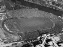
| Date: | 1952 |
|---|---|
| Description: | Aerial view of City Stadium, former home of the Green Bay Packers from 1925 to 1956. Currently it is the home of the Green Bay East High School football te... |
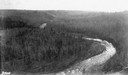
| Date: | |
|---|---|
| Description: | Aerial view of the Big Goose Neck in the Bad River at Copper Falls State Park. |

| Date: | 1951 |
|---|---|
| Description: | Aerial view of the Nekoosa-Edwards Paper Company nursery. |
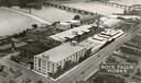
| Date: | 1931 |
|---|---|
| Description: | Aerial view of International Harvester's Rock Falls Works. The factory was owned by the Keystone Manufacturing Company until 1904, when the company was pur... |
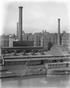
| Date: | 1911 |
|---|---|
| Description: | International Harvester's McCormick Works on the river with railroad tracks and a cargo dock. The factory was owned by the McCormick Harvesting Machine Com... |

| Date: | 1907 |
|---|---|
| Description: | Aerial view of the Mississippi River with log rafts. |

| Date: | 1930 |
|---|---|
| Description: | Aerial view of the city and the river. |

| Date: | 1955 |
|---|---|
| Description: | Aerial view of town, with the Baraboo River. |
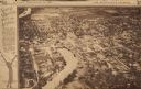
| Date: | 1923 |
|---|---|
| Description: | Aerial view of town with river. The clipping from a newspaper has a description titled: "Seeing Wisconsin From an Airplane". |

| Date: | 1965 |
|---|---|
| Description: | Aerial view of downtown Big Falls and the Little Wolf River. The Little Wolf River is at lower right. |
| Date: | 1948 |
|---|---|
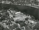
| Description: | St. Norbert College campus on the Fox River. |

| Date: | 1930 |
|---|---|
| Description: | Aerial view of Carson Park, Half Moon Lake and part of the West Side in the foreground. The municipal bath house is on the lake shore in the foreground. A ... |

| Date: | 1930 |
|---|---|
| Description: | Aerial view of city, with Eau Claire River is in the foreground with Milwaukee railroad bridge at left. Gillette Rubber Co. plant is in center with Omaha r... |

| Date: | 1931 |
|---|---|
| Description: | Aerial view looking north, with a small portion of the West Side (left), nearly all of the North Side and part of the business district of the East Side. A... |
| Date: | |
|---|---|
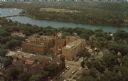
| Description: | Aerial view of the hospital along the banks of a river, with a bridge on the far left. Beyond the river is a baseball park. On the back of the card is writ... |
| Date: | |
|---|---|
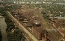
| Description: | Aerial view of the plant, with railroad tracks along both sides of the property. A river is on the left. Several cars are parked at the plant. There is an... |

| Date: | 1956 |
|---|---|
| Description: | Aerial view looking northeast from a point over the east end of Middleton, showing the west end of Lake Mendota (right mid-ground). Fox Bluff juts into the... |
If you didn't find the material you searched for, our Library Reference Staff can help.
Call our reference desk at 608-264-6535 or email us at:


