 Filter: Categories of Wisconsin Historical Images
Filter: Subject of Aerial photographs
Filter: Subject of neighborhoods
Filter: Categories of Wisconsin Historical Images
Filter: Subject of Aerial photographs
Filter: Subject of neighborhoods

| Date: | 1908 |
|---|---|
| Description: | Aerial view of Camp Randall Field on the University of Wisconsin-Madison campus. University Heights is in the background. |

| Date: | 06 07 1954 |
|---|---|
| Description: | Aerial view of the Midvale neighborhood under construction showing the intersection of Midvale and Tokay Boulevards near the southwestern city limits of Ma... |

| Date: | 1956 |
|---|---|
| Description: | Aerial view of the Chicago, Milwaukee, and St. Paul Railroad station, roundhouse, and yard at the intersection of West Washington Avenue (across lower left... |
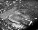
| Date: | 1934 |
|---|---|
| Description: | Aerial view of Camp Randall Stadium and Field House on the University of Wisconsin-Madison campus. |

| Date: | 1930 |
|---|---|
| Description: | Aerial view of Carson Park, Half Moon Lake and part of the West Side in the foreground. The municipal bath house is on the lake shore in the foreground. A ... |

| Date: | 1930 |
|---|---|
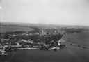
| Description: | Aerial view of city, with Eau Claire River is in the foreground with Milwaukee railroad bridge at left. Gillette Rubber Co. plant is in center with Omaha r... |
| Date: | 1945 |
|---|---|
| Description: | Aerial view of Madison over the University Avenue-Randall Stadium area, looking toward the Congregationalist Church and the U.S. Forest Products Laboratory... |

| Date: | 1955 |
|---|---|
| Description: | Aerial view of Atwood Avenue, looking west towards Winnebago Street and "Schenk's Corners." |

| Date: | 1953 |
|---|---|
| Description: | Aerial view looking southeast over Madison's near east side. The Eagles Club at 1236 Jenifer Street / 1221 Williamson Street is under construction in the ... |

| Date: | 1950 |
|---|---|
| Description: | Aerial view of fields near neighborhoods. |

| Date: | 07 24 1952 |
|---|---|
| Description: | Aerial view of the Wisconsin State Fair grounds, showing the GMC trucks tent and the residential neighborhood that bordered the grounds. |
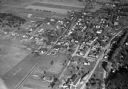
| Date: | 10 1928 |
|---|---|
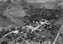
| Description: | Aerial view of DeForest including residences and the surrounding countryside. |

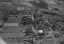
| Date: | 11 1928 |
|---|---|
| Description: | Aerial view of Verona including businesses, houses, and the surrounding farm land. |
| Date: | 11 1928 |
|---|---|
| Description: | Aerial view of Middleton including businesses, residences, the railroad tracks, and the surrounding countryside. |
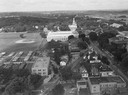
| Date: | 1930 |
|---|---|
| Description: | Aerial view of the Isthmus and the city of Madison including the downtown business district, the Wisconsin State Capitol, both Lake Mendota and Lake Monona... |

| Date: | 1930 |
|---|---|
| Description: | Aerial view of the University of Wisconsin-Madison campus, the State Historical Society of Wisconsin building, Lake Mendota, residential areas and the surr... |

| Date: | 1930 |
|---|---|
| Description: | Aerial view of the city with horizon in the far distance. Includes the Wisconsin State Capitol, businesses, Lake Monona, and the surrounding neighborhoods. |

| Date: | 11 1928 |
|---|---|
| Description: | Aerial view of Black Earth residential area and the surrounding countryside. |
| Date: | 11 1928 |
|---|---|
| Description: | Aerial view of Oregon, including the central business disctrict, residential areas, schools, and the surrounding countryside. |

| Date: | 1953 |
|---|---|
| Description: | Aerial view of Wonewoc with hills or bluffs in the foreground on the right. |
If you didn't find the material you searched for, our Library Reference Staff can help.
Call our reference desk at 608-264-6535 or email us at: