Filter: Categories of Wisconsin Historical Images
Filter: Subject of Aerial photographs
Filter: Subject of land use, urban
Filter: Categories of Wisconsin Historical Images
Filter: Subject of Aerial photographs
Filter: Subject of land use, urban

| Date: | 1956 |
|---|---|
| Description: | Aerial view of the South Park Street interchange. |
| Date: | 1925 |
|---|---|
| Description: | Aerial photograph taken as part of a survey by the Wisconsin Power and Light Company to promote economic development by emphasizing available buildings and... |

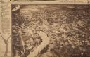
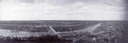
| Date: | 1908 |
|---|---|
| Description: | A panoramic aerial view of the Isthmus taken from a kite. Lake Mendota is to the right in the background with Picnic Point jutting into the lake. The photo... |

| Date: | 1964 |
|---|---|
| Description: | Aerial view of the Milwaukee County Zoo grounds nearing its completion. |

| Date: | 05 09 1908 |
|---|---|
| Description: | Kite aerial panoramic photograph of the central business district. In the distance is Lake Mendota. The fire damaged Wisconsin State Capitol is in the cent... |

| Date: | 11 16 2001 |
|---|---|
| Description: | Aerial view of General Mitchell International in Milwaukee, looking southeast to the Lake Michigan shoreline. |

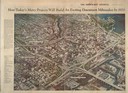
| Date: | 08 20 1930 |
|---|---|
| Description: | Aerial view of the Madison skyline from University of Wisconsin Field House, overlooking the Wisconsin State Capitol and, in the foreground, Gateway Lumber... |

| Date: | 1945 |
|---|---|
| Description: | View of the lower campus of the University of Wisconsin-Madison includes Bascom Hill, Wisconsin Historical Society, Memorial Union and the Armory (Red Gym ... |

| Date: | 1926 |
|---|---|
| Description: | Originally titled 'Recent Aeroplane View of University Campus', the view of the Wisconsin Historical Society, the Red Gym, Science Hall and Bascom Hall wit... |
| Date: | 03 09 1965 |
|---|---|
| Description: | Aerial view and illustration of projected projects, including interstates and interchanges in downtown Milwaukee, for the 1970's. |

| Date: | 1930 |
|---|---|
| Description: | Aerial view of the city and the river. |

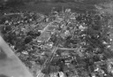
| Date: | 1955 |
|---|---|
| Description: | Aerial view of town, with the Baraboo River. |
| Date: | 1923 |
|---|---|
| Description: | Aerial view of town with river. The clipping from a newspaper has a description titled: "Seeing Wisconsin From an Airplane". |

| Date: | 1965 |
|---|---|
| Description: | Aerial view of downtown Big Falls and the Little Wolf River. The Little Wolf River is at lower right. |
| Date: | 1910 |
|---|---|
| Description: | Aerial view of town, with a river and the horizon in the distance. |

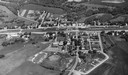
| Date: | 1955 |
|---|---|
| Description: | Aerial view of Cross Plains, with countryside surrounding and hills on the horizon. |
If you didn't find the material you searched for, our Library Reference Staff can help.
Call our reference desk at 608-264-6535 or email us at: