Filter: Categories of Wisconsin Historical Images
Filter: Subject of Aerial photographs
Filter: Subject of intellectual life
Filter: Categories of Wisconsin Historical Images
Filter: Subject of Aerial photographs
Filter: Subject of intellectual life
| Date: | 10 06 1928 |
|---|---|
| Description: | Aerial view of the Janesville airport during air races including airplanes in the air, the landing field, and airport structures. |
| Date: | 1930 |
|---|---|
| Description: | Aerial view of airplane races at the Janesville airport, including airplanes on the landing field, airport structures, cars parked around the airport, and ... |

| Date: | 1930 |
|---|---|
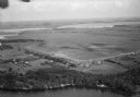
| Description: | Aerial view of Tenney Park, including the lagoon, residences surrounding the park, and the shoreline of Lake Mendota on bottom left. |

| Date: | 1930 |
|---|---|
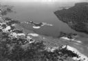
| Description: | Aerial view of Wisconsin Dells including the Wisconsin River and the dam and generating power plant. |
| Date: | 1930 |
|---|---|
| Description: | Aerial view of Lake Delton, the Wisconsin River, and the surrounding countryside. |

| Date: | 1930 |
|---|---|
| Description: | Aerial view of Hoyt Park including the surrounding neighborhoods. Resurrection Cemetery can be seen at the upper right of the image. |

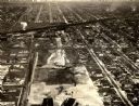
| Date: | 1930 |
|---|---|
| Description: | Aerial view of near west side, including West High School, the Forest Products Laboratory, Lake Mendota, and Picnic Point. |
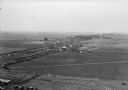
| Date: | |
|---|---|
| Description: | Aerial view of Pennco Field (Royal Airport), the shoreline of Lake Monona, and the surrounding countryside near the city limits. |

| Date: | 1930 |
|---|---|
| Description: | Aerial view of the Pennco Field (Royal Airport), including the hanger and airplanes on the ground. Lake Monona, the Wisconsin State Capitol, and the Madiso... |
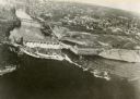
| Date: | 1932 |
|---|---|
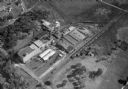
| Description: | Aerial view of the Oscar Mayer Meat Packing Plant and the surrounding neighborhoods on the east side. |

| Date: | |
|---|---|
| Description: | Aerial view of a crowd at the Pennco Field (Royal Airport), gathered for an aerial show. Biplanes possibly used for the show are on the airstrip. Automob... |

| Date: | 1930 |
|---|---|
| Description: | Aerial view of the Pennco Field (Royal Airport) hanger surrounded by spectators gathered for an air show. Biplanes are parked on the grounds of the airpor... |

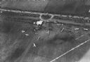
| Date: | 1930 |
|---|---|
| Description: | Aerial view of biplanes at the Pennco Field (Royal Airport), probably for an air show. Lake Monona is in the background. |
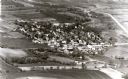
| Date: | 1865 |
|---|---|
| Description: | Aerial view of a residential part of Janesville. |

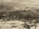
| Date: | 1909 |
|---|---|
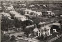
| Description: | Aerial view with the main street with railroad tracks in the foreground and houses in the background. There is also a church in the upper left corner. |
| Date: | 1940 |
|---|---|
| Description: | Aerial view of the Wisconsin Power and Light Company generating plant and dam. |
| Date: | 1934 |
|---|---|
| Description: | Aerial view of the play area for Roosevelt School. |

| Date: | 1930 |
|---|---|
| Description: | The city of West Allis, including an artist's rendition of the Allis-Chalmers Manufacturing Company. One of the largest machinery manufacturing plants in A... |
If you didn't find the material you searched for, our Library Reference Staff can help.
Call our reference desk at 608-264-6535 or email us at: