 Filter: Categories of Wisconsin Historical Images
Filter: Subject of Aerial photographs
Filter: Subject of human settlements
Filter: Creator Name of Calberne Studio, Inc.
Filter: Categories of Wisconsin Historical Images
Filter: Subject of Aerial photographs
Filter: Subject of human settlements
Filter: Creator Name of Calberne Studio, Inc.

| Date: | 1955 |
|---|---|
| Description: | Aerial view of river and its surrounding landscape. |

| Date: | 1950 |
|---|---|
| Description: | Aerial view of fields near neighborhoods. |

| Date: | 1950 |
|---|---|
| Description: | Aerial view of the confluence of the Fox River and Green Bay. |

| Date: | 1950 |
|---|---|
| Description: | Aerial view of the Fox River, near Green Bay. Handwritten locations are marked, including: Site of First Court House, Little Rapids, De Pere. |

| Date: | 1950 |
|---|---|
| Description: | Aerial view of the Highway 21 bridge and Petenwell Dam on the Wisconsin River. |
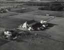
| Date: | 10 05 1948 |
|---|---|
| Description: | Aerial photograph of the Baumgartner Dairy Farm, one half mile east of Three Lakes, WI. |
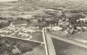
| Date: | 1921 |
|---|---|
| Description: | Text on reverse reads: "Southern Wisconsin Colony and Training School. Union Grove, Wis." Aerial view of a large facility. Opened in 1919 as the "Southern ... |
If you didn't find the material you searched for, our Library Reference Staff can help.
Call our reference desk at 608-264-6535 or email us at:
